You are here: Home > Network List > TA - USArray Transportable Network (new EarthScope stations) Stations List
> Station Y12C Blythe, CA, USA > Earthquake Result Viewer
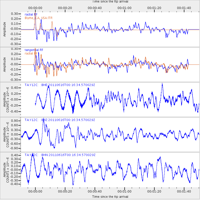
Y12C Blythe, CA, USA - Earthquake Result Viewer
*The percent match for this event was below the threshold and hence no stack was calculated.
| Earthquake location: |
New Britain Region, P.N.G. |
| Earthquake latitude/longitude: |
-5.9/151.0 |
| Earthquake time(UTC): |
2011/06/16 (167) 00:03:35 GMT |
| Earthquake Depth: |
16 km |
| Earthquake Magnitude: |
6.1 MB, 6.5 MS, 6.3 MW, 6.2 MW |
| Earthquake Catalog/Contributor: |
WHDF/NEIC |
|
| Network: |
TA USArray Transportable Network (new EarthScope stations) |
| Station: |
Y12C Blythe, CA, USA |
| Lat/Lon: |
33.75 N/114.52 W |
| Elevation: |
196 m |
|
| Distance: |
96.9 deg |
| Az: |
56.806 deg |
| Baz: |
267.521 deg |
| Ray Param: |
$rayparam |
*The percent match for this event was below the threshold and hence was not used in the summary stack. |
|
| Radial Match: |
73.65043 % |
| Radial Bump: |
400 |
| Transverse Match: |
61.192097 % |
| Transverse Bump: |
400 |
| SOD ConfigId: |
395004 |
| Insert Time: |
2011-11-27 01:31:00.164 +0000 |
| GWidth: |
2.5 |
| Max Bumps: |
400 |
| Tol: |
0.001 |
|
Signal To Noise
| Channel | StoN | STA | LTA |
| TA:Y12C: :BHZ:20110616T00:16:34.570029Z | 1.7246027 | 3.440278E-7 | 1.9948234E-7 |
| TA:Y12C: :BHN:20110616T00:16:34.570029Z | 1.7144909 | 1.8875919E-7 | 1.10096344E-7 |
| TA:Y12C: :BHE:20110616T00:16:34.570029Z | 0.6182038 | 1.4167033E-7 | 2.2916441E-7 |
| Arrivals |
| Ps | |
| PpPs | |
| PsPs/PpSs | |


