You are here: Home > Network List > TA - USArray Transportable Network (new EarthScope stations) Stations List
> Station I04A Tendick Farm, Oakridge, OR, USA > Earthquake Result Viewer
I04A Tendick Farm, Oakridge, OR, USA - Earthquake Result Viewer

| Earthquake location: |
New Britain Region, P.N.G. |
| Earthquake latitude/longitude: |
-5.9/151.0 |
| Earthquake time(UTC): |
2011/06/16 (167) 00:03:35 GMT |
| Earthquake Depth: |
16 km |
| Earthquake Magnitude: |
6.1 MB, 6.5 MS, 6.3 MW, 6.2 MW |
| Earthquake Catalog/Contributor: |
WHDF/NEIC |
|
| Network: |
TA USArray Transportable Network (new EarthScope stations) |
| Station: |
I04A Tendick Farm, Oakridge, OR, USA |
| Lat/Lon: |
43.79 N/122.41 W |
| Elevation: |
731 m |
|
| Distance: |
91.6 deg |
| Az: |
46.312 deg |
| Baz: |
263.36 deg |
| Ray Param: |
0.041587774 |
| Estimated Moho Depth: |
29.5 km |
| Estimated Crust Vp/Vs: |
1.91 |
| Assumed Crust Vp: |
6.522 km/s |
| Estimated Crust Vs: |
3.419 km/s |
| Estimated Crust Poisson's Ratio: |
0.31 |
|
| Radial Match: |
80.59602 % |
| Radial Bump: |
400 |
| Transverse Match: |
59.78009 % |
| Transverse Bump: |
400 |
| SOD ConfigId: |
395004 |
| Insert Time: |
2011-11-27 01:31:12.196 +0000 |
| GWidth: |
2.5 |
| Max Bumps: |
400 |
| Tol: |
0.001 |
|
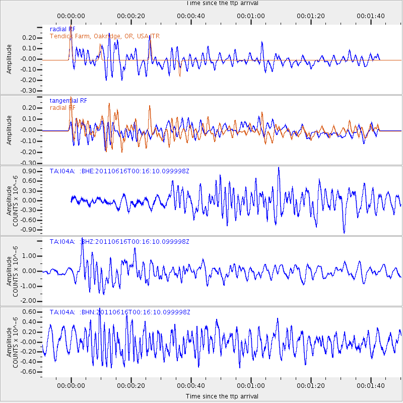
Signal To Noise
| Channel | StoN | STA | LTA |
| TA:I04A: :BHZ:20110616T00:16:10.099998Z | 6.064382 | 7.6153344E-7 | 1.2557477E-7 |
| TA:I04A: :BHN:20110616T00:16:10.099998Z | 1.2896092 | 2.0055965E-7 | 1.5551971E-7 |
| TA:I04A: :BHE:20110616T00:16:10.099998Z | 2.3549407 | 2.4794028E-7 | 1.0528515E-7 |
| Arrivals |
| Ps | 4.2 SECOND |
| PpPs | 13 SECOND |
| PsPs/PpSs | 17 SECOND |


