You are here: Home > Network List > TA - USArray Transportable Network (new EarthScope stations) Stations List
> Station R11A Troy Canyon, Currant, NV, USA > Earthquake Result Viewer
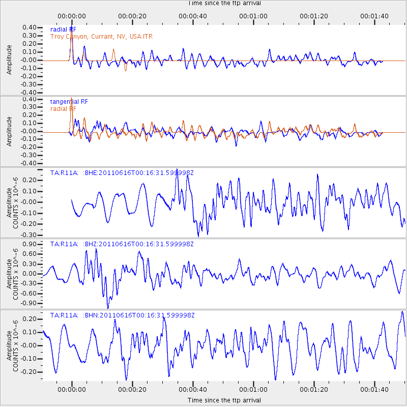
R11A Troy Canyon, Currant, NV, USA - Earthquake Result Viewer
*The percent match for this event was below the threshold and hence no stack was calculated.
| Earthquake location: |
New Britain Region, P.N.G. |
| Earthquake latitude/longitude: |
-5.9/151.0 |
| Earthquake time(UTC): |
2011/06/16 (167) 00:03:35 GMT |
| Earthquake Depth: |
16 km |
| Earthquake Magnitude: |
6.1 MB, 6.5 MS, 6.3 MW, 6.2 MW |
| Earthquake Catalog/Contributor: |
WHDF/NEIC |
|
| Network: |
TA USArray Transportable Network (new EarthScope stations) |
| Station: |
R11A Troy Canyon, Currant, NV, USA |
| Lat/Lon: |
38.35 N/115.59 W |
| Elevation: |
1756 m |
|
| Distance: |
96.3 deg |
| Az: |
52.153 deg |
| Baz: |
267.435 deg |
| Ray Param: |
$rayparam |
*The percent match for this event was below the threshold and hence was not used in the summary stack. |
|
| Radial Match: |
70.57029 % |
| Radial Bump: |
400 |
| Transverse Match: |
61.019997 % |
| Transverse Bump: |
400 |
| SOD ConfigId: |
395004 |
| Insert Time: |
2011-11-27 01:31:13.105 +0000 |
| GWidth: |
2.5 |
| Max Bumps: |
400 |
| Tol: |
0.001 |
|
Signal To Noise
| Channel | StoN | STA | LTA |
| TA:R11A: :BHZ:20110616T00:16:31.599998Z | 2.5508711 | 2.7861864E-7 | 1.092249E-7 |
| TA:R11A: :BHN:20110616T00:16:31.599998Z | 0.84568673 | 7.9529954E-8 | 9.404186E-8 |
| TA:R11A: :BHE:20110616T00:16:31.599998Z | 1.1637177 | 9.9453175E-8 | 8.54616E-8 |
| Arrivals |
| Ps | |
| PpPs | |
| PsPs/PpSs | |


