You are here: Home > Network List > UW - Pacific Northwest Regional Seismic Network Stations List
> Station PASS Maple Falls, WA, USA > Earthquake Result Viewer
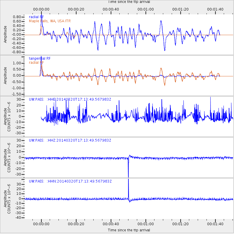
PASS Maple Falls, WA, USA - Earthquake Result Viewer
*The percent match for this event was below the threshold and hence no stack was calculated.
| Earthquake location: |
New Britain Region, P.N.G. |
| Earthquake latitude/longitude: |
-5.2/152.9 |
| Earthquake time(UTC): |
2014/03/20 (079) 17:01:24 GMT |
| Earthquake Depth: |
53 km |
| Earthquake Magnitude: |
5.4 MW |
| Earthquake Catalog/Contributor: |
ISC/ISC |
|
| Network: |
UW Pacific Northwest Regional Seismic Network |
| Station: |
PASS Maple Falls, WA, USA |
| Lat/Lon: |
49.00 N/122.09 W |
| Elevation: |
174 m |
|
| Distance: |
90.6 deg |
| Az: |
41.009 deg |
| Baz: |
262.881 deg |
| Ray Param: |
$rayparam |
*The percent match for this event was below the threshold and hence was not used in the summary stack. |
|
| Radial Match: |
53.688217 % |
| Radial Bump: |
400 |
| Transverse Match: |
97.12303 % |
| Transverse Bump: |
171 |
| SOD ConfigId: |
3390531 |
| Insert Time: |
2019-04-10 18:53:04.293 +0000 |
| GWidth: |
2.5 |
| Max Bumps: |
400 |
| Tol: |
0.001 |
|
Signal To Noise
| Channel | StoN | STA | LTA |
| UW:PASS: :HHZ:20140320T17:13:49.567983Z | 0.88479745 | 1.0598612E-6 | 1.1978574E-6 |
| UW:PASS: :HHN:20140320T17:13:49.567983Z | 0.8292822 | 1.1030039E-6 | 1.3300706E-6 |
| UW:PASS: :HHE:20140320T17:13:49.567983Z | 0.3970483 | 3.0615422E-6 | 7.710755E-6 |
| Arrivals |
| Ps | |
| PpPs | |
| PsPs/PpSs | |


