You are here: Home > Network List > BK - Berkeley Digital Seismograph Network Stations List
> Station HUMO Hull Mountain, OR > Earthquake Result Viewer
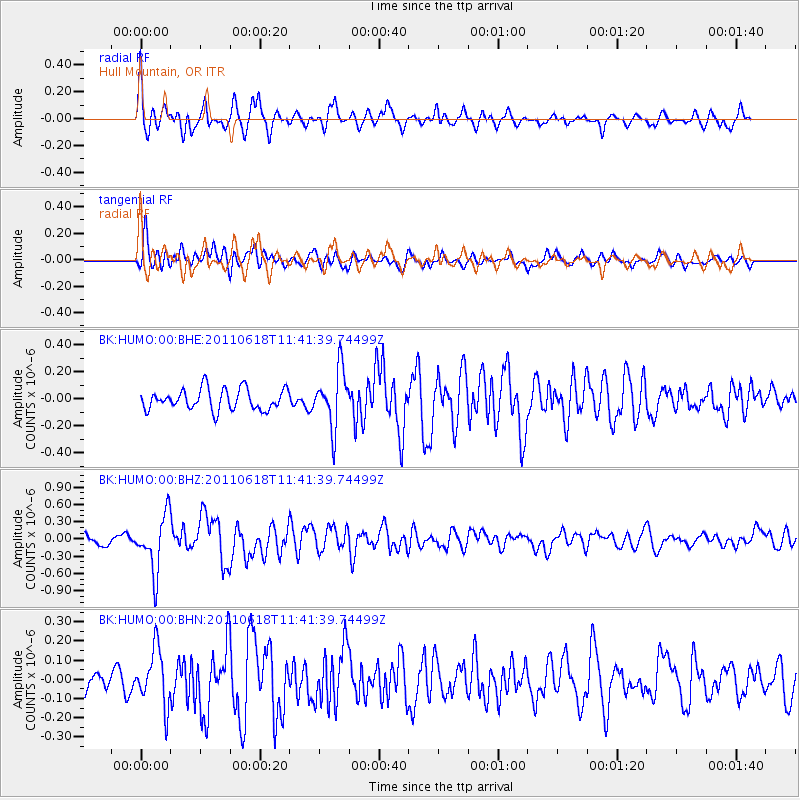
HUMO Hull Mountain, OR - Earthquake Result Viewer
*The percent match for this event was below the threshold and hence no stack was calculated.
| Earthquake location: |
Near East Coast Of Honshu, Japan |
| Earthquake latitude/longitude: |
37.7/141.7 |
| Earthquake time(UTC): |
2011/06/18 (169) 11:31:05 GMT |
| Earthquake Depth: |
20 km |
| Earthquake Magnitude: |
5.9 MB, 5.4 MS, 5.8 MW, 5.6 MW |
| Earthquake Catalog/Contributor: |
WHDF/NEIC |
|
| Network: |
BK Berkeley Digital Seismograph Network |
| Station: |
HUMO Hull Mountain, OR |
| Lat/Lon: |
42.61 N/122.96 W |
| Elevation: |
555 m |
|
| Distance: |
69.2 deg |
| Az: |
51.849 deg |
| Baz: |
302.296 deg |
| Ray Param: |
$rayparam |
*The percent match for this event was below the threshold and hence was not used in the summary stack. |
|
| Radial Match: |
74.0068 % |
| Radial Bump: |
400 |
| Transverse Match: |
71.54475 % |
| Transverse Bump: |
400 |
| SOD ConfigId: |
395004 |
| Insert Time: |
2011-12-01 04:35:01.274 +0000 |
| GWidth: |
2.5 |
| Max Bumps: |
400 |
| Tol: |
0.001 |
|
Signal To Noise
| Channel | StoN | STA | LTA |
| BK:HUMO:00:BHZ:20110618T11:41:39.74499Z | 4.3809094 | 4.878647E-7 | 1.1136151E-7 |
| BK:HUMO:00:BHN:20110618T11:41:39.74499Z | 2.2621617 | 1.4619211E-7 | 6.462496E-8 |
| BK:HUMO:00:BHE:20110618T11:41:39.74499Z | 2.7358844 | 2.1118082E-7 | 7.718923E-8 |
| Arrivals |
| Ps | |
| PpPs | |
| PsPs/PpSs | |


