You are here: Home > Network List > TA - USArray Transportable Network (new EarthScope stations) Stations List
> Station A29A Manning Farm, Rocklake, ND, USA > Earthquake Result Viewer
A29A Manning Farm, Rocklake, ND, USA - Earthquake Result Viewer

| Earthquake location: |
Near East Coast Of Honshu, Japan |
| Earthquake latitude/longitude: |
37.7/141.7 |
| Earthquake time(UTC): |
2011/06/18 (169) 11:31:05 GMT |
| Earthquake Depth: |
20 km |
| Earthquake Magnitude: |
5.9 MB, 5.4 MS, 5.8 MW, 5.6 MW |
| Earthquake Catalog/Contributor: |
WHDF/NEIC |
|
| Network: |
TA USArray Transportable Network (new EarthScope stations) |
| Station: |
A29A Manning Farm, Rocklake, ND, USA |
| Lat/Lon: |
48.92 N/99.23 W |
| Elevation: |
480 m |
|
| Distance: |
78.3 deg |
| Az: |
36.052 deg |
| Baz: |
314.92 deg |
| Ray Param: |
0.04971512 |
| Estimated Moho Depth: |
10.0 km |
| Estimated Crust Vp/Vs: |
1.60 |
| Assumed Crust Vp: |
6.53 km/s |
| Estimated Crust Vs: |
4.082 km/s |
| Estimated Crust Poisson's Ratio: |
0.18 |
|
| Radial Match: |
84.92451 % |
| Radial Bump: |
400 |
| Transverse Match: |
66.837234 % |
| Transverse Bump: |
400 |
| SOD ConfigId: |
395004 |
| Insert Time: |
2011-12-01 04:53:20.571 +0000 |
| GWidth: |
2.5 |
| Max Bumps: |
400 |
| Tol: |
0.001 |
|
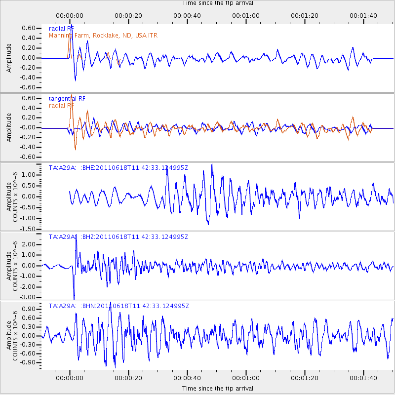
Signal To Noise
| Channel | StoN | STA | LTA |
| TA:A29A: :BHZ:20110618T11:42:33.124995Z | 10.107407 | 1.1611647E-6 | 1.1488255E-7 |
| TA:A29A: :BHN:20110618T11:42:33.124995Z | 1.7050972 | 4.12093E-7 | 2.4168298E-7 |
| TA:A29A: :BHE:20110618T11:42:33.124995Z | 2.630488 | 5.490676E-7 | 2.0873223E-7 |
| Arrivals |
| Ps | 1.0 SECOND |
| PpPs | 3.8 SECOND |
| PsPs/PpSs | 4.8 SECOND |


