You are here: Home > Network List > TA - USArray Transportable Network (new EarthScope stations) Stations List
> Station 435B Jarrell, TX, USA > Earthquake Result Viewer
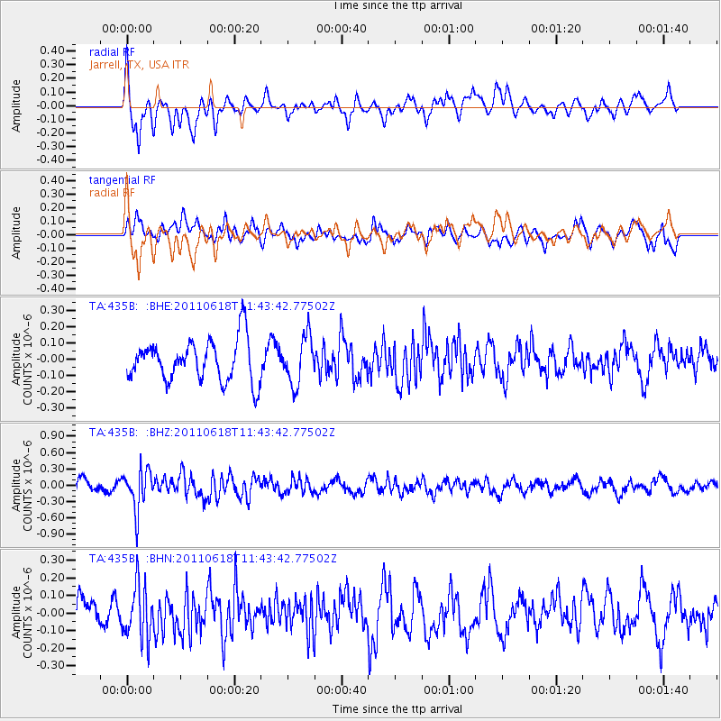
435B Jarrell, TX, USA - Earthquake Result Viewer
*The percent match for this event was below the threshold and hence no stack was calculated.
| Earthquake location: |
Near East Coast Of Honshu, Japan |
| Earthquake latitude/longitude: |
37.7/141.7 |
| Earthquake time(UTC): |
2011/06/18 (169) 11:31:05 GMT |
| Earthquake Depth: |
20 km |
| Earthquake Magnitude: |
5.9 MB, 5.4 MS, 5.8 MW, 5.6 MW |
| Earthquake Catalog/Contributor: |
WHDF/NEIC |
|
| Network: |
TA USArray Transportable Network (new EarthScope stations) |
| Station: |
435B Jarrell, TX, USA |
| Lat/Lon: |
30.78 N/97.58 W |
| Elevation: |
248 m |
|
| Distance: |
92.3 deg |
| Az: |
47.747 deg |
| Baz: |
316.958 deg |
| Ray Param: |
$rayparam |
*The percent match for this event was below the threshold and hence was not used in the summary stack. |
|
| Radial Match: |
73.09994 % |
| Radial Bump: |
400 |
| Transverse Match: |
52.657166 % |
| Transverse Bump: |
400 |
| SOD ConfigId: |
395004 |
| Insert Time: |
2011-12-01 05:00:22.239 +0000 |
| GWidth: |
2.5 |
| Max Bumps: |
400 |
| Tol: |
0.001 |
|
Signal To Noise
| Channel | StoN | STA | LTA |
| TA:435B: :BHZ:20110618T11:43:42.77502Z | 3.2067838 | 3.6759246E-7 | 1.14629636E-7 |
| TA:435B: :BHN:20110618T11:43:42.77502Z | 2.0539227 | 1.5352079E-7 | 7.474516E-8 |
| TA:435B: :BHE:20110618T11:43:42.77502Z | 1.1639798 | 1.4827128E-7 | 1.2738305E-7 |
| Arrivals |
| Ps | |
| PpPs | |
| PsPs/PpSs | |


