You are here: Home > Network List > TA - USArray Transportable Network (new EarthScope stations) Stations List
> Station Y37A Hugo, OK, USA > Earthquake Result Viewer
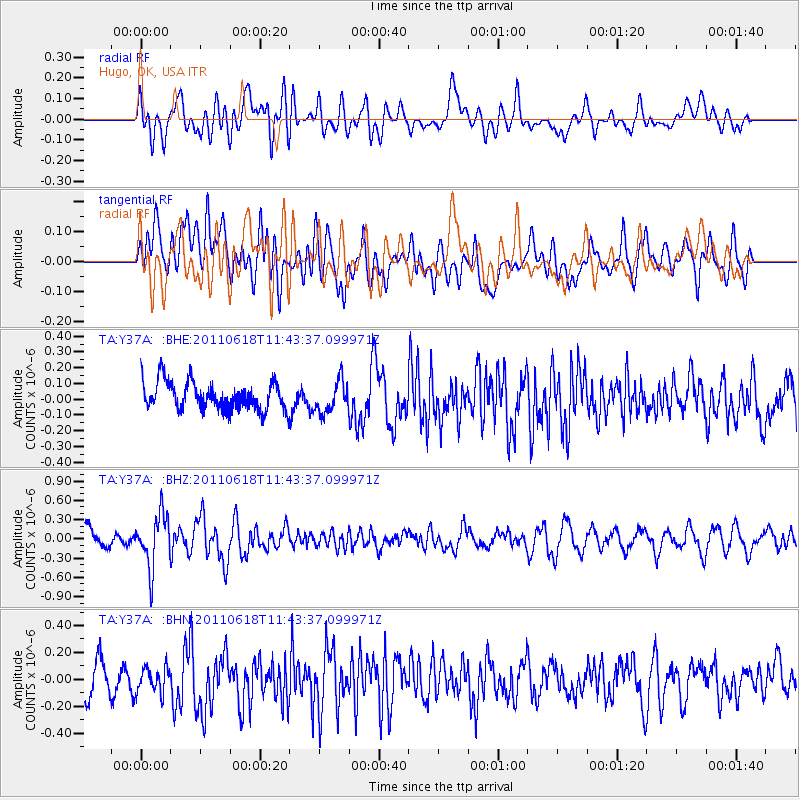
Y37A Hugo, OK, USA - Earthquake Result Viewer
*The percent match for this event was below the threshold and hence no stack was calculated.
| Earthquake location: |
Near East Coast Of Honshu, Japan |
| Earthquake latitude/longitude: |
37.7/141.7 |
| Earthquake time(UTC): |
2011/06/18 (169) 11:31:05 GMT |
| Earthquake Depth: |
20 km |
| Earthquake Magnitude: |
5.9 MB, 5.4 MS, 5.8 MW, 5.6 MW |
| Earthquake Catalog/Contributor: |
WHDF/NEIC |
|
| Network: |
TA USArray Transportable Network (new EarthScope stations) |
| Station: |
Y37A Hugo, OK, USA |
| Lat/Lon: |
33.98 N/95.62 W |
| Elevation: |
165 m |
|
| Distance: |
91.0 deg |
| Az: |
44.369 deg |
| Baz: |
318.102 deg |
| Ray Param: |
$rayparam |
*The percent match for this event was below the threshold and hence was not used in the summary stack. |
|
| Radial Match: |
63.10772 % |
| Radial Bump: |
400 |
| Transverse Match: |
59.20092 % |
| Transverse Bump: |
400 |
| SOD ConfigId: |
395004 |
| Insert Time: |
2011-12-01 05:03:15.776 +0000 |
| GWidth: |
2.5 |
| Max Bumps: |
400 |
| Tol: |
0.001 |
|
Signal To Noise
| Channel | StoN | STA | LTA |
| TA:Y37A: :BHZ:20110618T11:43:37.099971Z | 3.1990132 | 4.1176745E-7 | 1.2871702E-7 |
| TA:Y37A: :BHN:20110618T11:43:37.099971Z | 0.8525511 | 9.736033E-8 | 1.1419881E-7 |
| TA:Y37A: :BHE:20110618T11:43:37.099971Z | 1.1364703 | 9.9920456E-8 | 8.792174E-8 |
| Arrivals |
| Ps | |
| PpPs | |
| PsPs/PpSs | |


