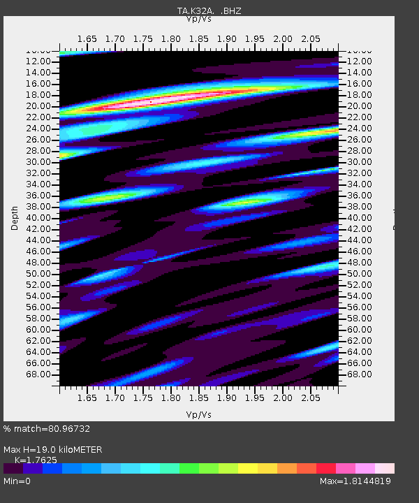
K32A Verdigre, NE, USA - Earthquake Result Viewer
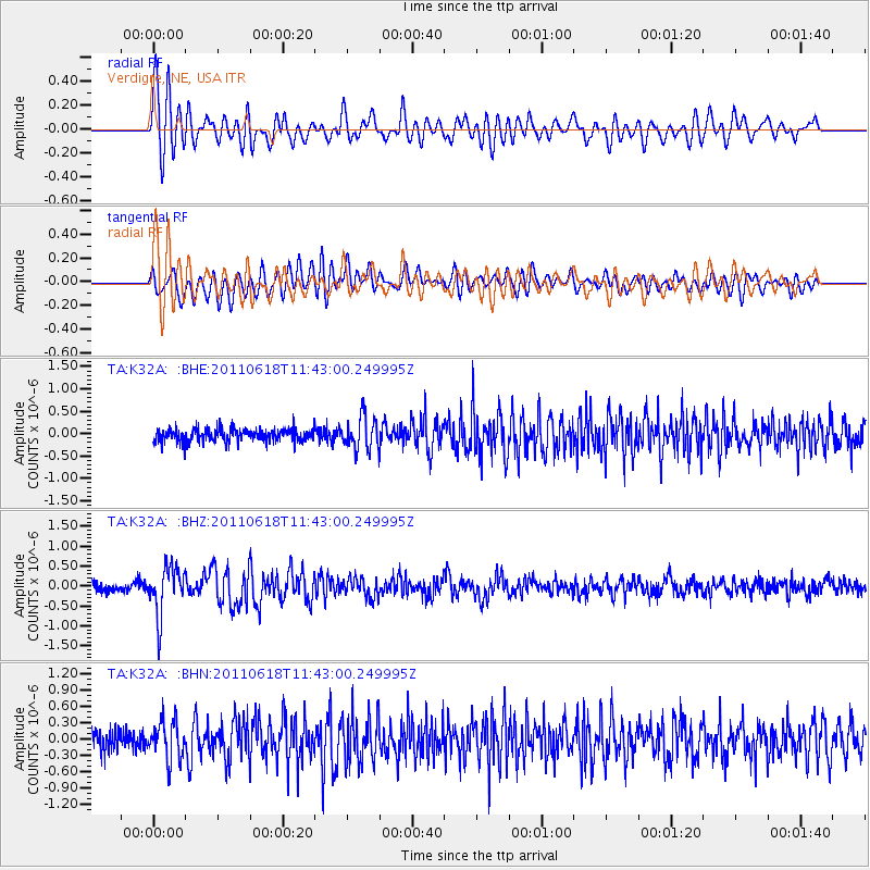
Earthquake location: Near East Coast Of Honshu, Japan
Earthquake latitude/longitude: 37.7/141.7
Earthquake time(UTC): 2011/06/18 (169) 11:31:05 GMT
Earthquake Depth: 20 km
Earthquake Magnitude: 5.9 MB, 5.4 MS, 5.8 MW, 5.6 MW
Earthquake Catalog/Contributor: WHDF/NEIC
Network: TA USArray Transportable Network (new EarthScope stations)
Station: K32A Verdigre, NE, USA
Lat/Lon: 42.66 N/97.97 W
Elevation: 512 m
Distance: 83.4 deg
Az: 39.845 deg
Baz: 316.425 deg
Ray Param: 0.046196364
Estimated Moho Depth: 19.0 km
Estimated Crust Vp/Vs: 1.76
Assumed Crust Vp: 6.498 km/s
Estimated Crust Vs: 3.687 km/s
Estimated Crust Poisson's Ratio: 0.26
Radial Match: 80.96732 %
Radial Bump: 400
Transverse Match: 75.86777 %
Transverse Bump: 400
SOD ConfigId: 395004
Insert Time: 2011-12-01 05:06:38.904 +0000
GWidth: 2.5
Max Bumps: 400
Tol: 0.001

Signal To Noise

ChannelStoNSTALTA
TA:K32A: :BHZ:20110618T11:43:00.249995Z5.6762295.997256E-71.05655644E-7
TA:K32A: :BHN:20110618T11:43:00.249995Z2.18916963.4575254E-71.5793775E-7
TA:K32A: :BHE:20110618T11:43:00.249995Z2.4629823.512472E-71.4261055E-7
Arrivals
Ps2.3 SECOND
PpPs7.9 SECOND
PsPs/PpSs10 SECOND