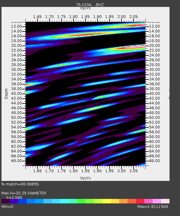
K33A Hardington, NE, USA - Earthquake Result Viewer
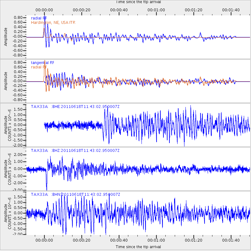
Earthquake location: Near East Coast Of Honshu, Japan
Earthquake latitude/longitude: 37.7/141.7
Earthquake time(UTC): 2011/06/18 (169) 11:31:05 GMT
Earthquake Depth: 20 km
Earthquake Magnitude: 5.9 MB, 5.4 MS, 5.8 MW, 5.6 MW
Earthquake Catalog/Contributor: WHDF/NEIC
Network: TA USArray Transportable Network (new EarthScope stations)
Station: K33A Hardington, NE, USA
Lat/Lon: 42.61 N/97.00 W
Elevation: 507 m
Distance: 83.9 deg
Az: 39.358 deg
Baz: 317.027 deg
Ray Param: 0.04581804
Estimated Moho Depth: 20.25 km
Estimated Crust Vp/Vs: 2.07
Assumed Crust Vp: 6.498 km/s
Estimated Crust Vs: 3.147 km/s
Estimated Crust Poisson's Ratio: 0.35
Radial Match: 88.86955 %
Radial Bump: 400
Transverse Match: 85.452385 %
Transverse Bump: 400
SOD ConfigId: 395004
Insert Time: 2011-12-01 05:06:41.816 +0000
GWidth: 2.5
Max Bumps: 400
Tol: 0.001

Signal To Noise

ChannelStoNSTALTA
TA:K33A: :BHZ:20110618T11:43:02.950007Z4.99224149.127063E-71.8282495E-7
TA:K33A: :BHN:20110618T11:43:02.950007Z2.41508845.2111744E-72.1577571E-7
TA:K33A: :BHE:20110618T11:43:02.950007Z4.3782818.603523E-71.9650457E-7
Arrivals
Ps3.4 SECOND
PpPs9.3 SECOND
PsPs/PpSs13 SECOND