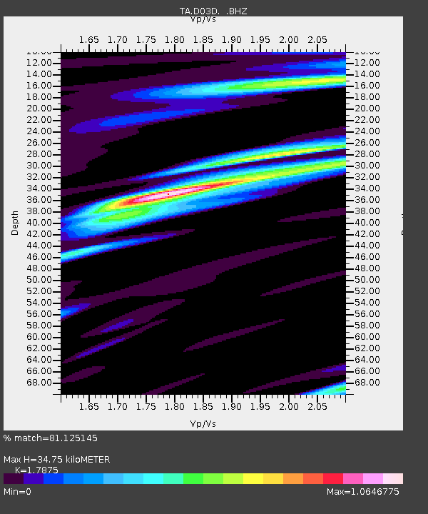
D03D Eldon, WA, USA - Earthquake Result Viewer

Earthquake location: Near East Coast Of Honshu, Japan
Earthquake latitude/longitude: 37.7/141.7
Earthquake time(UTC): 2011/06/18 (169) 11:31:05 GMT
Earthquake Depth: 20 km
Earthquake Magnitude: 5.9 MB, 5.4 MS, 5.8 MW, 5.6 MW
Earthquake Catalog/Contributor: WHDF/NEIC
Network: TA USArray Transportable Network (new EarthScope stations)
Station: D03D Eldon, WA, USA
Lat/Lon: 47.53 N/123.09 W
Elevation: 262 m
Distance: 66.5 deg
Az: 47.361 deg
Baz: 300.509 deg
Ray Param: 0.05753579
Estimated Moho Depth: 34.75 km
Estimated Crust Vp/Vs: 1.79
Assumed Crust Vp: 6.566 km/s
Estimated Crust Vs: 3.673 km/s
Estimated Crust Poisson's Ratio: 0.27
Radial Match: 81.125145 %
Radial Bump: 400
Transverse Match: 86.12561 %
Transverse Bump: 400
SOD ConfigId: 395004
Insert Time: 2011-12-01 05:10:37.755 +0000
GWidth: 2.5
Max Bumps: 400
Tol: 0.001

Signal To Noise

ChannelStoNSTALTA
TA:D03D: :BHZ:20110618T11:41:23.124995Z8.7915358.2142276E-79.343337E-8
TA:D03D: :BHN:20110618T11:41:23.124995Z3.27128462.1048355E-76.4342785E-8
TA:D03D: :BHE:20110618T11:41:23.124995Z4.0399982.5744575E-76.372422E-8
Arrivals
Ps4.3 SECOND
PpPs14 SECOND
PsPs/PpSs18 SECOND