You are here: Home > Network List > TA - USArray Transportable Network (new EarthScope stations) Stations List
> Station Z45A Winona, MS, USA > Earthquake Result Viewer
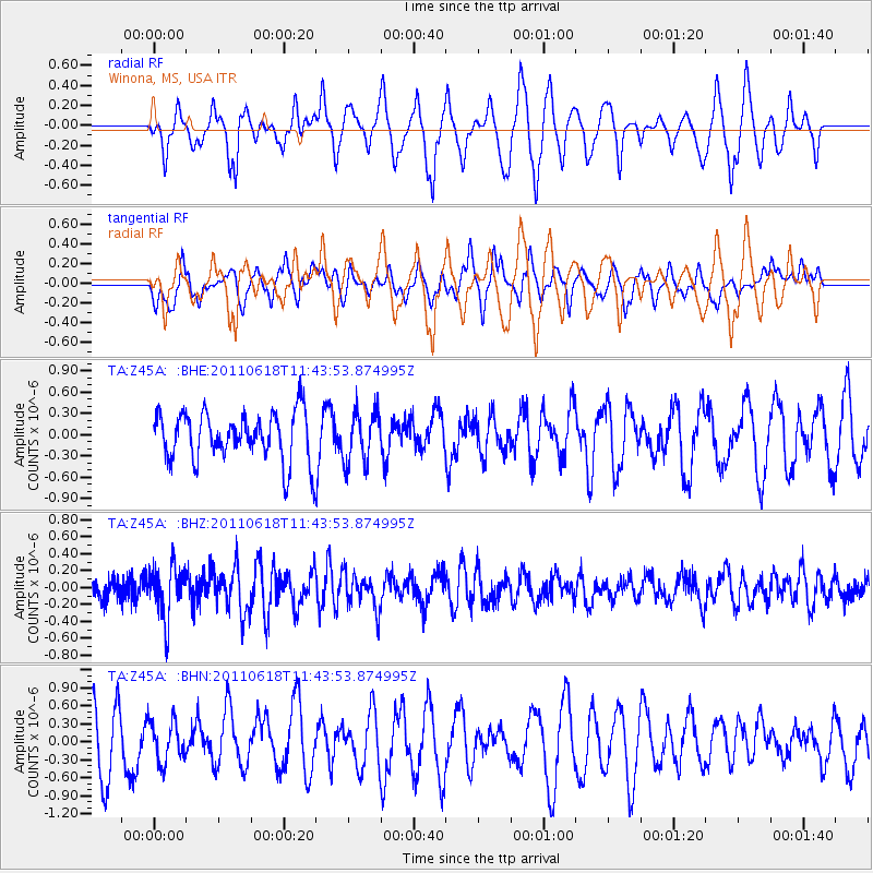
Z45A Winona, MS, USA - Earthquake Result Viewer
*The percent match for this event was below the threshold and hence no stack was calculated.
| Earthquake location: |
Near East Coast Of Honshu, Japan |
| Earthquake latitude/longitude: |
37.7/141.7 |
| Earthquake time(UTC): |
2011/06/18 (169) 11:31:05 GMT |
| Earthquake Depth: |
20 km |
| Earthquake Magnitude: |
5.9 MB, 5.4 MS, 5.8 MW, 5.6 MW |
| Earthquake Catalog/Contributor: |
WHDF/NEIC |
|
| Network: |
TA USArray Transportable Network (new EarthScope stations) |
| Station: |
Z45A Winona, MS, USA |
| Lat/Lon: |
33.37 N/89.69 W |
| Elevation: |
113 m |
|
| Distance: |
94.7 deg |
| Az: |
40.978 deg |
| Baz: |
321.546 deg |
| Ray Param: |
$rayparam |
*The percent match for this event was below the threshold and hence was not used in the summary stack. |
|
| Radial Match: |
52.988354 % |
| Radial Bump: |
325 |
| Transverse Match: |
58.022068 % |
| Transverse Bump: |
400 |
| SOD ConfigId: |
395004 |
| Insert Time: |
2011-12-01 05:21:04.593 +0000 |
| GWidth: |
2.5 |
| Max Bumps: |
400 |
| Tol: |
0.001 |
|
Signal To Noise
| Channel | StoN | STA | LTA |
| TA:Z45A: :BHZ:20110618T11:43:53.874995Z | 1.9125744 | 2.951518E-7 | 1.5432174E-7 |
| TA:Z45A: :BHN:20110618T11:43:53.874995Z | 0.8046314 | 3.346359E-7 | 4.1588717E-7 |
| TA:Z45A: :BHE:20110618T11:43:53.874995Z | 1.0524204 | 3.6077012E-7 | 3.4280038E-7 |
| Arrivals |
| Ps | |
| PpPs | |
| PsPs/PpSs | |


