You are here: Home > Network List > TA - USArray Transportable Network (new EarthScope stations) Stations List
> Station S44A Carbondale, IL, USA > Earthquake Result Viewer
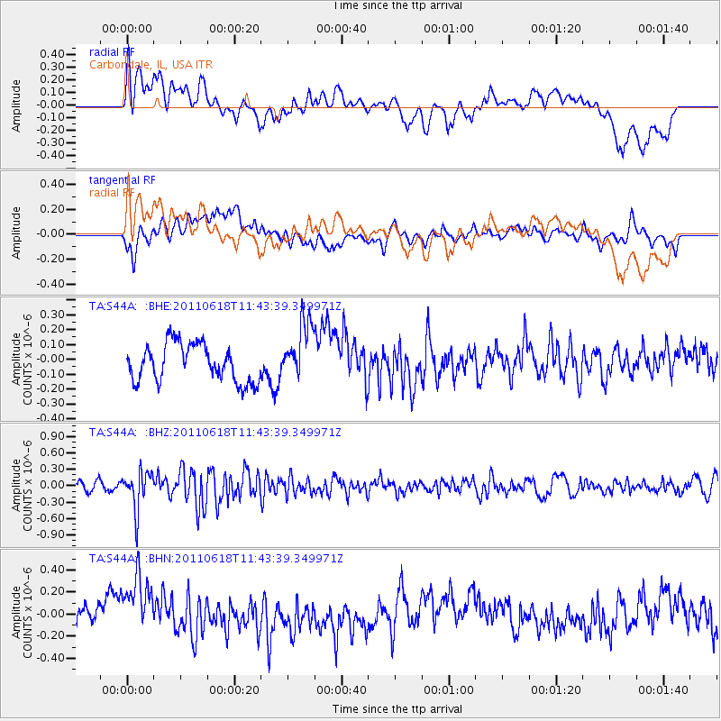
S44A Carbondale, IL, USA - Earthquake Result Viewer
*The percent match for this event was below the threshold and hence no stack was calculated.
| Earthquake location: |
Near East Coast Of Honshu, Japan |
| Earthquake latitude/longitude: |
37.7/141.7 |
| Earthquake time(UTC): |
2011/06/18 (169) 11:31:05 GMT |
| Earthquake Depth: |
20 km |
| Earthquake Magnitude: |
5.9 MB, 5.4 MS, 5.8 MW, 5.6 MW |
| Earthquake Catalog/Contributor: |
WHDF/NEIC |
|
| Network: |
TA USArray Transportable Network (new EarthScope stations) |
| Station: |
S44A Carbondale, IL, USA |
| Lat/Lon: |
37.69 N/89.26 W |
| Elevation: |
155 m |
|
| Distance: |
91.5 deg |
| Az: |
38.024 deg |
| Baz: |
321.958 deg |
| Ray Param: |
$rayparam |
*The percent match for this event was below the threshold and hence was not used in the summary stack. |
|
| Radial Match: |
58.971584 % |
| Radial Bump: |
400 |
| Transverse Match: |
35.035027 % |
| Transverse Bump: |
400 |
| SOD ConfigId: |
395004 |
| Insert Time: |
2011-12-01 05:22:27.988 +0000 |
| GWidth: |
2.5 |
| Max Bumps: |
400 |
| Tol: |
0.001 |
|
Signal To Noise
| Channel | StoN | STA | LTA |
| TA:S44A: :BHZ:20110618T11:43:39.349971Z | 3.9886456 | 3.4757568E-7 | 8.714128E-8 |
| TA:S44A: :BHN:20110618T11:43:39.349971Z | 3.1206465 | 3.0396848E-7 | 9.740561E-8 |
| TA:S44A: :BHE:20110618T11:43:39.349971Z | 1.569906 | 1.971452E-7 | 1.255777E-7 |
| Arrivals |
| Ps | |
| PpPs | |
| PsPs/PpSs | |


