You are here: Home > Network List > CI - Caltech Regional Seismic Network Stations List
> Station MPP McPhearson Peak > Earthquake Result Viewer
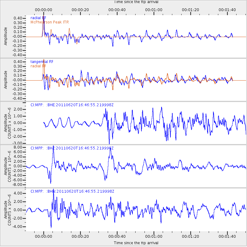
MPP McPhearson Peak - Earthquake Result Viewer
*The percent match for this event was below the threshold and hence no stack was calculated.
| Earthquake location: |
Chile-Bolivia Border Region |
| Earthquake latitude/longitude: |
-21.7/-68.2 |
| Earthquake time(UTC): |
2011/06/20 (171) 16:36:01 GMT |
| Earthquake Depth: |
128 km |
| Earthquake Magnitude: |
6.0 MB, 6.5 MW, 6.5 MW |
| Earthquake Catalog/Contributor: |
WHDF/NEIC |
|
| Network: |
CI Caltech Regional Seismic Network |
| Station: |
MPP McPhearson Peak |
| Lat/Lon: |
34.89 N/119.81 W |
| Elevation: |
1739 m |
|
| Distance: |
74.6 deg |
| Az: |
318.077 deg |
| Baz: |
130.901 deg |
| Ray Param: |
$rayparam |
*The percent match for this event was below the threshold and hence was not used in the summary stack. |
|
| Radial Match: |
79.34257 % |
| Radial Bump: |
400 |
| Transverse Match: |
76.70417 % |
| Transverse Bump: |
400 |
| SOD ConfigId: |
395004 |
| Insert Time: |
2011-12-01 05:49:24.572 +0000 |
| GWidth: |
2.5 |
| Max Bumps: |
400 |
| Tol: |
0.001 |
|
Signal To Noise
| Channel | StoN | STA | LTA |
| CI:MPP: :BHZ:20110620T16:46:55.219998Z | 6.848186 | 2.6639386E-6 | 3.8899913E-7 |
| CI:MPP: :BHN:20110620T16:46:55.219998Z | 2.0253623 | 1.2077711E-6 | 5.963235E-7 |
| CI:MPP: :BHE:20110620T16:46:55.219998Z | 2.097301 | 8.394906E-7 | 4.0027186E-7 |
| Arrivals |
| Ps | |
| PpPs | |
| PsPs/PpSs | |


