You are here: Home > Network List > CI - Caltech Regional Seismic Network Stations List
> Station SCZ2 SCZ2, Santa Cruz Is. (E end), CA, USA > Earthquake Result Viewer
SCZ2 SCZ2, Santa Cruz Is. (E end), CA, USA - Earthquake Result Viewer
| Earthquake location: |
Chile-Bolivia Border Region |
| Earthquake latitude/longitude: |
-21.7/-68.2 |
| Earthquake time(UTC): |
2011/06/20 (171) 16:36:01 GMT |
| Earthquake Depth: |
128 km |
| Earthquake Magnitude: |
6.0 MB, 6.5 MW, 6.5 MW |
| Earthquake Catalog/Contributor: |
WHDF/NEIC |
|
| Network: |
CI Caltech Regional Seismic Network |
| Station: |
SCZ2 SCZ2, Santa Cruz Is. (E end), CA, USA |
| Lat/Lon: |
34.00 N/119.64 W |
| Elevation: |
440 m |
|
| Distance: |
73.9 deg |
| Az: |
317.477 deg |
| Baz: |
130.839 deg |
| Ray Param: |
0.052375577 |
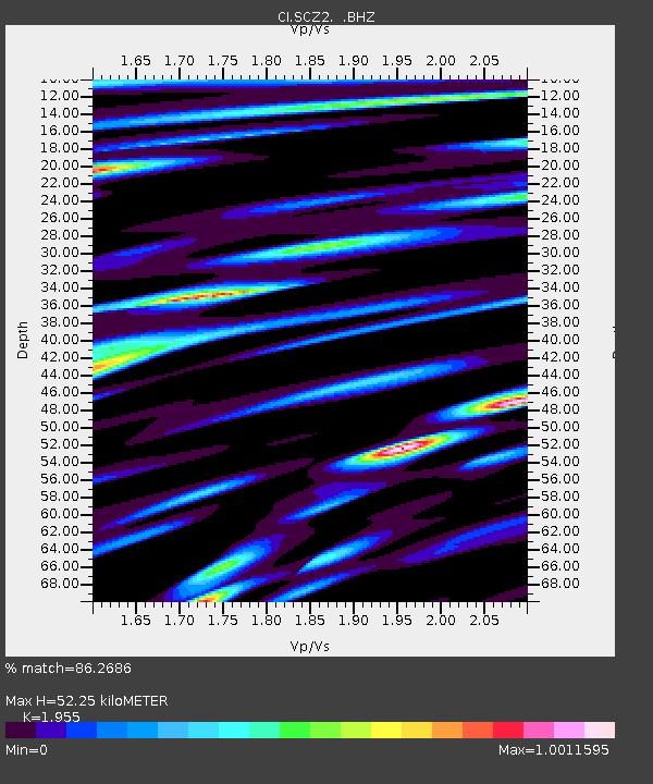
| Estimated Moho Depth: |
52.25 km |
| Estimated Crust Vp/Vs: |
1.96 |
| Assumed Crust Vp: |
6.048 km/s |
| Estimated Crust Vs: |
3.094 km/s |
| Estimated Crust Poisson's Ratio: |
0.32 |
|
| Radial Match: |
86.2686 % |
| Radial Bump: |
400 |
| Transverse Match: |
86.76198 % |
| Transverse Bump: |
400 |
| SOD ConfigId: |
395004 |
| Insert Time: |
2011-12-01 05:50:38.626 +0000 |
| GWidth: |
2.5 |
| Max Bumps: |
400 |
| Tol: |
0.001 |
|
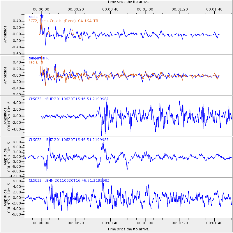
Signal To Noise
| Channel | StoN | STA | LTA |
| CI:SCZ2: :BHZ:20110620T16:46:51.219998Z | 8.599776 | 4.4819885E-6 | 5.21175E-7 |
| CI:SCZ2: :BHN:20110620T16:46:51.219998Z | 2.6804757 | 1.5694818E-6 | 5.855236E-7 |
| CI:SCZ2: :BHE:20110620T16:46:51.219998Z | 4.8792915 | 1.2733773E-6 | 2.6097584E-7 |
| Arrivals |
| Ps | 8.5 SECOND |
| PpPs | 25 SECOND |
| PsPs/PpSs | 33 SECOND |


