You are here: Home > Network List > CD - China Digital Seismograph Network Stations List
> Station WMQ Urumqi, Xinjiang Province, China > Earthquake Result Viewer
WMQ Urumqi, Xinjiang Province, China - Earthquake Result Viewer
| Earthquake location: |
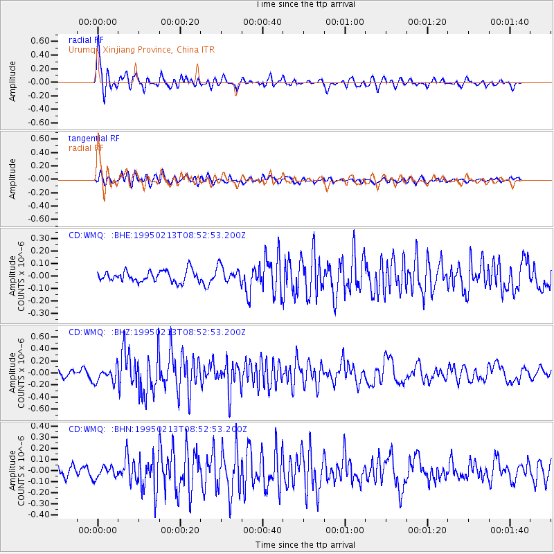
Halmahera, Indonesia |
| Earthquake latitude/longitude: |
-1.3/127.4 |
| Earthquake time(UTC): |
1995/02/13 (044) 08:43:39 GMT |
| Earthquake Depth: |
33 km |
| Earthquake Magnitude: |
6.1 MB, 6.2 MS, 6.2 UNKNOWN, 6.2 MW |
| Earthquake Catalog/Contributor: |
WHDF/NEIC |
|
| Network: |
CD China Digital Seismograph Network |
| Station: |
WMQ Urumqi, Xinjiang Province, China |
| Lat/Lon: |
43.82 N/87.69 E |
| Elevation: |
903 m |
|
| Distance: |
57.3 deg |
| Az: |
326.632 deg |
| Baz: |
130.564 deg |
| Ray Param: |
0.06355225 |
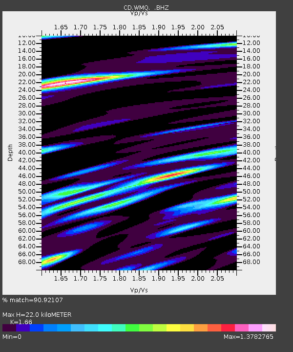
| Estimated Moho Depth: |
22.0 km |
| Estimated Crust Vp/Vs: |
1.66 |
| Assumed Crust Vp: |
6.242 km/s |
| Estimated Crust Vs: |
3.76 km/s |
| Estimated Crust Poisson's Ratio: |
0.22 |
|
| Radial Match: |
90.92107 % |
| Radial Bump: |
400 |
| Transverse Match: |
74.8134 % |
| Transverse Bump: |
400 |
| SOD ConfigId: |
4480 |
| Insert Time: |
2010-02-26 21:24:26.843 +0000 |
| GWidth: |
2.5 |
| Max Bumps: |
400 |
| Tol: |
0.001 |
|
Signal To Noise
| Channel | StoN | STA | LTA |
| CD:WMQ: :BHZ:19950213T08:52:53.200Z | 2.600453 | 1.230711E-7 | 4.7326793E-8 |
| CD:WMQ: :BHN:19950213T08:52:53.200Z | 1.2266611 | 5.0773227E-8 | 4.139141E-8 |
| CD:WMQ: :BHE:19950213T08:52:53.200Z | 1.4797508 | 6.475807E-8 | 4.3762824E-8 |
| Arrivals |
| Ps | 2.4 SECOND |
| PpPs | 8.9 SECOND |
| PsPs/PpSs | 11 SECOND |


