You are here: Home > Network List > IW - Intermountain West Stations List
> Station MOOW Moose Ponds, Wyoming, USA > Earthquake Result Viewer
MOOW Moose Ponds, Wyoming, USA - Earthquake Result Viewer
| Earthquake location: |
Chile-Bolivia Border Region |
| Earthquake latitude/longitude: |
-21.7/-68.2 |
| Earthquake time(UTC): |
2011/06/20 (171) 16:36:01 GMT |
| Earthquake Depth: |
128 km |
| Earthquake Magnitude: |
6.0 MB, 6.5 MW, 6.5 MW |
| Earthquake Catalog/Contributor: |
WHDF/NEIC |
|
| Network: |
IW Intermountain West |
| Station: |
MOOW Moose Ponds, Wyoming, USA |
| Lat/Lon: |
43.75 N/110.74 W |
| Elevation: |
2128 m |
|
| Distance: |
75.9 deg |
| Az: |
329.672 deg |
| Baz: |
139.611 deg |
| Ray Param: |
0.05103725 |
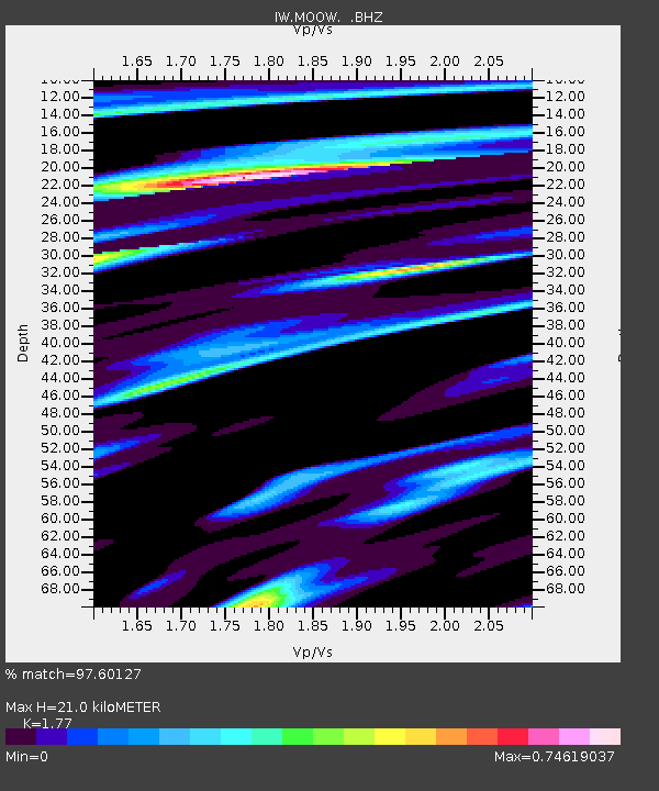
| Estimated Moho Depth: |
21.0 km |
| Estimated Crust Vp/Vs: |
1.77 |
| Assumed Crust Vp: |
6.207 km/s |
| Estimated Crust Vs: |
3.507 km/s |
| Estimated Crust Poisson's Ratio: |
0.27 |
|
| Radial Match: |
97.60127 % |
| Radial Bump: |
400 |
| Transverse Match: |
92.58759 % |
| Transverse Bump: |
400 |
| SOD ConfigId: |
395004 |
| Insert Time: |
2011-12-01 05:54:28.166 +0000 |
| GWidth: |
2.5 |
| Max Bumps: |
400 |
| Tol: |
0.001 |
|
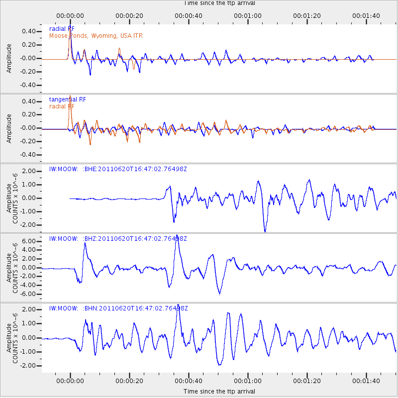
Signal To Noise
| Channel | StoN | STA | LTA |
| IW:MOOW: :BHZ:20110620T16:47:02.76498Z | 41.581673 | 2.026419E-6 | 4.873346E-8 |
| IW:MOOW: :BHN:20110620T16:47:02.76498Z | 13.721728 | 4.7676926E-7 | 3.4745568E-8 |
| IW:MOOW: :BHE:20110620T16:47:02.76498Z | 18.293463 | 5.161771E-7 | 2.8216478E-8 |
| Arrivals |
| Ps | 2.7 SECOND |
| PpPs | 9.1 SECOND |
| PsPs/PpSs | 12 SECOND |


