You are here: Home > Network List > CD - China Digital Seismograph Network Stations List
> Station WMQ Urumqi, Xinjiang Province, China > Earthquake Result Viewer
WMQ Urumqi, Xinjiang Province, China - Earthquake Result Viewer
| Earthquake location: |
Near North Coast Of Irian Jaya |
| Earthquake latitude/longitude: |
-2.1/140.4 |
| Earthquake time(UTC): |
1995/04/18 (108) 03:49:39 GMT |
| Earthquake Depth: |
36 km |
| Earthquake Magnitude: |
5.9 MB, 5.7 MS, 5.6 UNKNOWN, 6.1 MW |
| Earthquake Catalog/Contributor: |
WHDF/NEIC |
|
| Network: |
CD China Digital Seismograph Network |
| Station: |
WMQ Urumqi, Xinjiang Province, China |
| Lat/Lon: |
43.82 N/87.69 E |
| Elevation: |
903 m |
|
| Distance: |
65.6 deg |
| Az: |
320.756 deg |
| Baz: |
119.141 deg |
| Ray Param: |
0.05809319 |
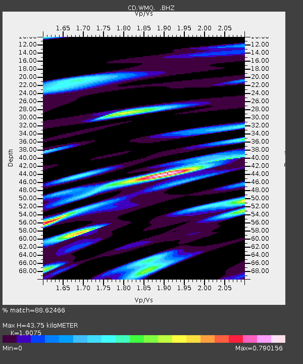
| Estimated Moho Depth: |
43.75 km |
| Estimated Crust Vp/Vs: |
1.91 |
| Assumed Crust Vp: |
6.242 km/s |
| Estimated Crust Vs: |
3.272 km/s |
| Estimated Crust Poisson's Ratio: |
0.31 |
|
| Radial Match: |
88.62466 % |
| Radial Bump: |
400 |
| Transverse Match: |
75.3728 % |
| Transverse Bump: |
400 |
| SOD ConfigId: |
4480 |
| Insert Time: |
2010-02-26 21:24:28.056 +0000 |
| GWidth: |
2.5 |
| Max Bumps: |
400 |
| Tol: |
0.001 |
|

Signal To Noise
| Channel | StoN | STA | LTA |
| CD:WMQ: :BHZ:19950418T03:59:48.670007Z | 13.349658 | 1.1164896E-7 | 8.363432E-9 |
| CD:WMQ: :BHN:19950418T03:59:48.670007Z | 2.4366164 | 1.6005815E-8 | 6.568869E-9 |
| CD:WMQ: :BHE:19950418T03:59:48.670007Z | 4.823503 | 3.4013418E-8 | 7.0516006E-9 |
| Arrivals |
| Ps | 6.6 SECOND |
| PpPs | 20 SECOND |
| PsPs/PpSs | 26 SECOND |


