You are here: Home > Network List > NE - New England Seismic Network Stations List
> Station WES Weston, MA > Earthquake Result Viewer
WES Weston, MA - Earthquake Result Viewer
| Earthquake location: |
Chile-Bolivia Border Region |
| Earthquake latitude/longitude: |
-21.7/-68.2 |
| Earthquake time(UTC): |
2011/06/20 (171) 16:36:01 GMT |
| Earthquake Depth: |
128 km |
| Earthquake Magnitude: |
6.0 MB, 6.5 MW, 6.5 MW |
| Earthquake Catalog/Contributor: |
WHDF/NEIC |
|
| Network: |
NE New England Seismic Network |
| Station: |
WES Weston, MA |
| Lat/Lon: |
42.38 N/71.32 W |
| Elevation: |
60 m |
|
| Distance: |
63.8 deg |
| Az: |
357.446 deg |
| Baz: |
176.794 deg |
| Ray Param: |
0.05895895 |
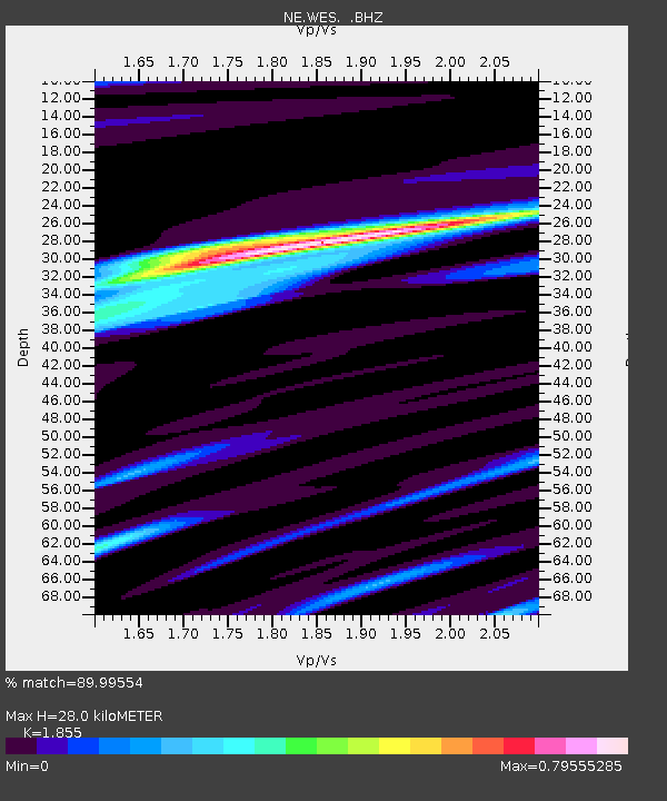
| Estimated Moho Depth: |
28.0 km |
| Estimated Crust Vp/Vs: |
1.86 |
| Assumed Crust Vp: |
6.419 km/s |
| Estimated Crust Vs: |
3.461 km/s |
| Estimated Crust Poisson's Ratio: |
0.30 |
|
| Radial Match: |
89.99554 % |
| Radial Bump: |
400 |
| Transverse Match: |
62.4319 % |
| Transverse Bump: |
400 |
| SOD ConfigId: |
395004 |
| Insert Time: |
2011-12-01 05:57:04.217 +0000 |
| GWidth: |
2.5 |
| Max Bumps: |
400 |
| Tol: |
0.001 |
|

Signal To Noise
| Channel | StoN | STA | LTA |
| NE:WES: :BHZ:20110620T16:45:49.079983Z | 4.9954267 | 5.346119E-7 | 1.0702027E-7 |
| NE:WES: :BHN:20110620T16:45:49.079983Z | 2.2650065 | 3.949993E-7 | 1.7439211E-7 |
| NE:WES: :BHE:20110620T16:45:49.079983Z | 1.12958 | 1.346513E-7 | 1.19204756E-7 |
| Arrivals |
| Ps | 3.9 SECOND |
| PpPs | 12 SECOND |
| PsPs/PpSs | 16 SECOND |


