You are here: Home > Network List > PM - Portuguese National Seismic Network Stations List
> Station PESTR ESTREMOZ, PORTUGAL > Earthquake Result Viewer
PESTR ESTREMOZ, PORTUGAL - Earthquake Result Viewer
| Earthquake location: |
Chile-Bolivia Border Region |
| Earthquake latitude/longitude: |
-21.7/-68.2 |
| Earthquake time(UTC): |
2011/06/20 (171) 16:36:01 GMT |
| Earthquake Depth: |
128 km |
| Earthquake Magnitude: |
6.0 MB, 6.5 MW, 6.5 MW |
| Earthquake Catalog/Contributor: |
WHDF/NEIC |
|
| Network: |
PM Portuguese National Seismic Network |
| Station: |
PESTR ESTREMOZ, PORTUGAL |
| Lat/Lon: |
38.87 N/7.59 W |
| Elevation: |
410 m |
|
| Distance: |
82.7 deg |
| Az: |
43.303 deg |
| Baz: |
234.79 deg |
| Ray Param: |
0.04638358 |
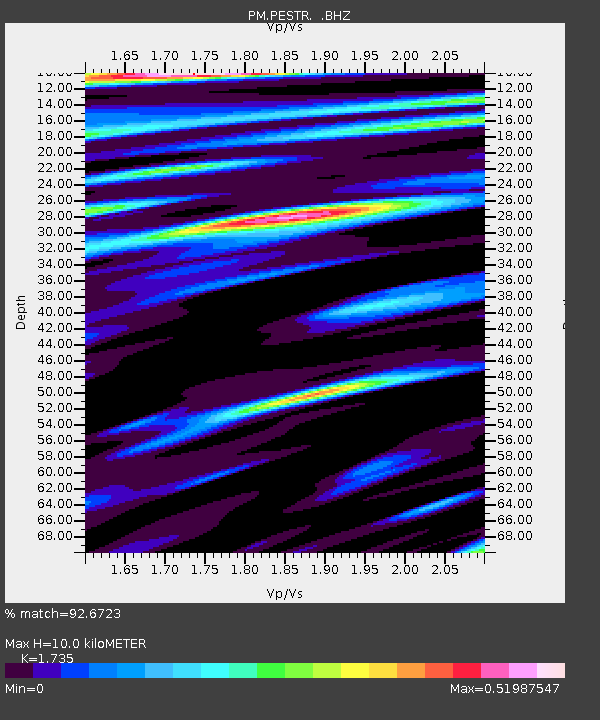
| Estimated Moho Depth: |
10.0 km |
| Estimated Crust Vp/Vs: |
1.74 |
| Assumed Crust Vp: |
6.276 km/s |
| Estimated Crust Vs: |
3.617 km/s |
| Estimated Crust Poisson's Ratio: |
0.25 |
|
| Radial Match: |
92.6723 % |
| Radial Bump: |
400 |
| Transverse Match: |
87.31041 % |
| Transverse Bump: |
400 |
| SOD ConfigId: |
395004 |
| Insert Time: |
2011-12-01 05:59:26.773 +0000 |
| GWidth: |
2.5 |
| Max Bumps: |
400 |
| Tol: |
0.001 |
|

Signal To Noise
| Channel | StoN | STA | LTA |
| PM:PESTR: :BHZ:20110620T16:47:39.704983Z | 27.722345 | 1.0912089E-6 | 3.936207E-8 |
| PM:PESTR: :BHN:20110620T16:47:39.685024Z | 5.30031 | 2.1902551E-7 | 4.1323148E-8 |
| PM:PESTR: :BHE:20110620T16:47:39.714993Z | 8.161671 | 2.9460818E-7 | 3.6096555E-8 |
| Arrivals |
| Ps | 1.2 SECOND |
| PpPs | 4.2 SECOND |
| PsPs/PpSs | 5.5 SECOND |


