You are here: Home > Network List > TA - USArray Transportable Network (new EarthScope stations) Stations List
> Station H17A Grant Village (NPS), Yellowstone Nt. Park, WY, USA > Earthquake Result Viewer
H17A Grant Village (NPS), Yellowstone Nt. Park, WY, USA - Earthquake Result Viewer
| Earthquake location: |
Chile-Bolivia Border Region |
| Earthquake latitude/longitude: |
-21.7/-68.2 |
| Earthquake time(UTC): |
2011/06/20 (171) 16:36:01 GMT |
| Earthquake Depth: |
128 km |
| Earthquake Magnitude: |
6.0 MB, 6.5 MW, 6.5 MW |
| Earthquake Catalog/Contributor: |
WHDF/NEIC |
|
| Network: |
TA USArray Transportable Network (new EarthScope stations) |
| Station: |
H17A Grant Village (NPS), Yellowstone Nt. Park, WY, USA |
| Lat/Lon: |
44.40 N/110.58 W |
| Elevation: |
2400 m |
|
| Distance: |
76.3 deg |
| Az: |
330.198 deg |
| Baz: |
139.854 deg |
| Ray Param: |
0.050760724 |
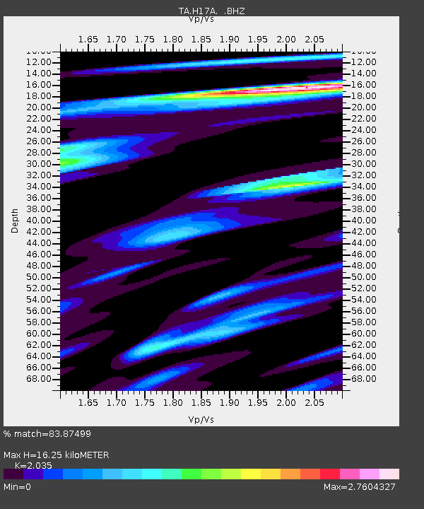
| Estimated Moho Depth: |
16.25 km |
| Estimated Crust Vp/Vs: |
2.04 |
| Assumed Crust Vp: |
6.35 km/s |
| Estimated Crust Vs: |
3.12 km/s |
| Estimated Crust Poisson's Ratio: |
0.34 |
|
| Radial Match: |
83.87499 % |
| Radial Bump: |
400 |
| Transverse Match: |
89.49418 % |
| Transverse Bump: |
400 |
| SOD ConfigId: |
395004 |
| Insert Time: |
2011-12-01 06:13:08.650 +0000 |
| GWidth: |
2.5 |
| Max Bumps: |
400 |
| Tol: |
0.001 |
|
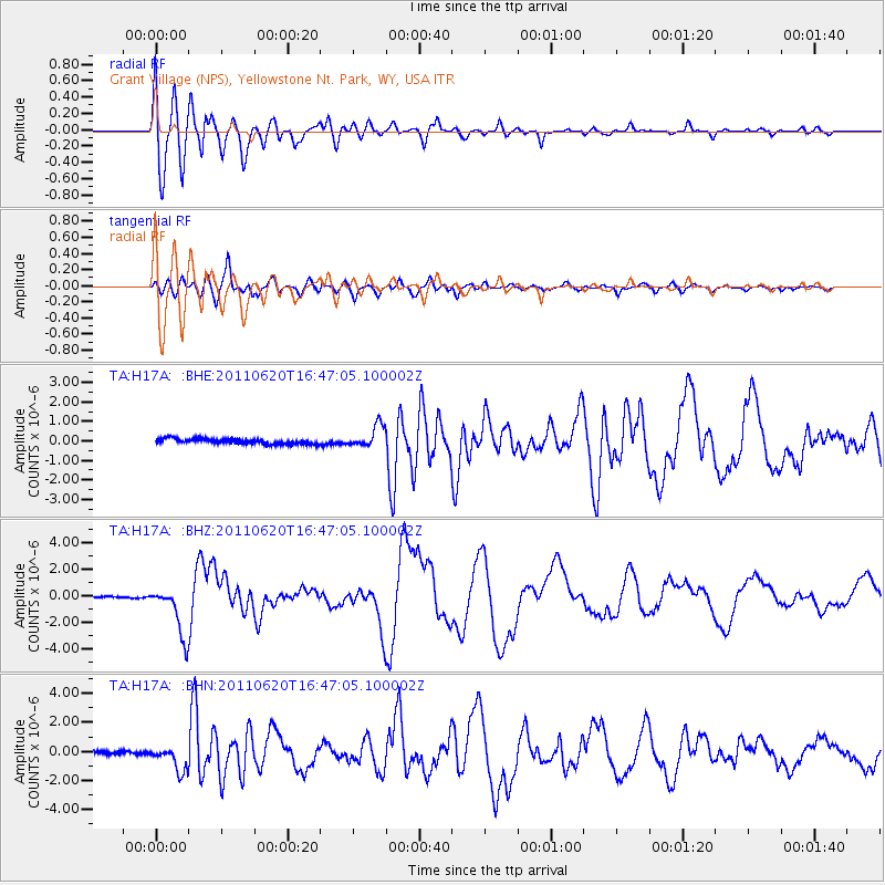
Signal To Noise
| Channel | StoN | STA | LTA |
| TA:H17A: :BHZ:20110620T16:47:05.100002Z | 27.580338 | 1.8824637E-6 | 6.825383E-8 |
| TA:H17A: :BHN:20110620T16:47:05.100002Z | 7.031346 | 8.4598395E-7 | 1.2031607E-7 |
| TA:H17A: :BHE:20110620T16:47:05.100002Z | 4.4985185 | 5.7286877E-7 | 1.273461E-7 |
| Arrivals |
| Ps | 2.7 SECOND |
| PpPs | 7.6 SECOND |
| PsPs/PpSs | 10 SECOND |


