You are here: Home > Network List > TA - USArray Transportable Network (new EarthScope stations) Stations List
> Station F25A Bowman, SD, USA > Earthquake Result Viewer
F25A Bowman, SD, USA - Earthquake Result Viewer
| Earthquake location: |
Chile-Bolivia Border Region |
| Earthquake latitude/longitude: |
-21.7/-68.2 |
| Earthquake time(UTC): |
2011/06/20 (171) 16:36:01 GMT |
| Earthquake Depth: |
128 km |
| Earthquake Magnitude: |
6.0 MB, 6.5 MW, 6.5 MW |
| Earthquake Catalog/Contributor: |
WHDF/NEIC |
|
| Network: |
TA USArray Transportable Network (new EarthScope stations) |
| Station: |
F25A Bowman, SD, USA |
| Lat/Lon: |
45.93 N/103.46 W |
| Elevation: |
912 m |
|
| Distance: |
74.5 deg |
| Az: |
335.304 deg |
| Baz: |
146.174 deg |
| Ray Param: |
0.051964015 |
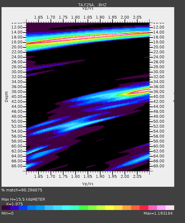
| Estimated Moho Depth: |
15.5 km |
| Estimated Crust Vp/Vs: |
1.88 |
| Assumed Crust Vp: |
6.242 km/s |
| Estimated Crust Vs: |
3.329 km/s |
| Estimated Crust Poisson's Ratio: |
0.30 |
|
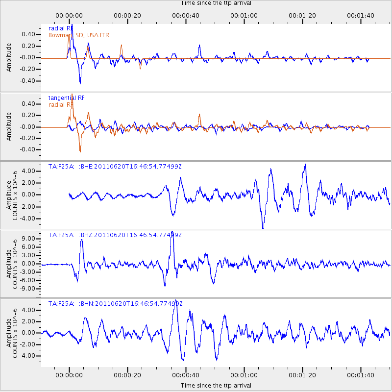
| Radial Match: |
98.296875 % |
| Radial Bump: |
261 |
| Transverse Match: |
85.34235 % |
| Transverse Bump: |
400 |
| SOD ConfigId: |
395004 |
| Insert Time: |
2011-12-01 06:14:49.235 +0000 |
| GWidth: |
2.5 |
| Max Bumps: |
400 |
| Tol: |
0.001 |
|
Signal To Noise
| Channel | StoN | STA | LTA |
| TA:F25A: :BHZ:20110620T16:46:54.77499Z | 23.448576 | 4.123458E-6 | 1.758511E-7 |
| TA:F25A: :BHN:20110620T16:46:54.77499Z | 3.8332179 | 8.759155E-7 | 2.2850658E-7 |
| TA:F25A: :BHE:20110620T16:46:54.77499Z | 2.8910315 | 9.0269856E-7 | 3.1224099E-7 |
| Arrivals |
| Ps | 2.2 SECOND |
| PpPs | 6.9 SECOND |
| PsPs/PpSs | 9.2 SECOND |


