You are here: Home > Network List > CD - China Digital Seismograph Network Stations List
> Station WMQ Urumqi, Xinjiang Province, China > Earthquake Result Viewer
WMQ Urumqi, Xinjiang Province, China - Earthquake Result Viewer

| Earthquake location: |
Philippine Islands Region |
| Earthquake latitude/longitude: |
19.8/122.5 |
| Earthquake time(UTC): |
1993/05/18 (138) 10:19:38 GMT |
| Earthquake Depth: |
214 km |
| Earthquake Magnitude: |
6.1 MB |
| Earthquake Catalog/Contributor: |
WHDF/NEIC |
|
| Network: |
CD China Digital Seismograph Network |
| Station: |
WMQ Urumqi, Xinjiang Province, China |
| Lat/Lon: |
43.82 N/87.69 E |
| Elevation: |
903 m |
|
| Distance: |
37.6 deg |
| Az: |
317.414 deg |
| Baz: |
118.332 deg |
| Ray Param: |
0.07521692 |
| Estimated Moho Depth: |
20.25 km |
| Estimated Crust Vp/Vs: |
1.78 |
| Assumed Crust Vp: |
6.242 km/s |
| Estimated Crust Vs: |
3.502 km/s |
| Estimated Crust Poisson's Ratio: |
0.27 |
|
| Radial Match: |
87.396355 % |
| Radial Bump: |
400 |
| Transverse Match: |
79.0045 % |
| Transverse Bump: |
400 |
| SOD ConfigId: |
4480 |
| Insert Time: |
2010-02-26 21:24:37.260 +0000 |
| GWidth: |
2.5 |
| Max Bumps: |
400 |
| Tol: |
0.001 |
|
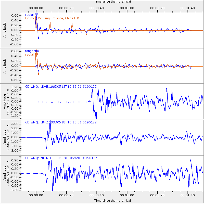
Signal To Noise
| Channel | StoN | STA | LTA |
| CD:WMQ: :BHZ:19930518T10:26:01.619012Z | 2.6464932 | 3.8131535E-8 | 1.4408325E-8 |
| CD:WMQ: :BHN:19930518T10:26:01.619012Z | 0.8578072 | 9.104838E-9 | 1.0614084E-8 |
| CD:WMQ: :BHE:19930518T10:26:01.619012Z | 1.2496625 | 1.5990361E-8 | 1.2795744E-8 |
| Arrivals |
| Ps | 2.7 SECOND |
| PpPs | 8.4 SECOND |
| PsPs/PpSs | 11 SECOND |


