You are here: Home > Network List > TA - USArray Transportable Network (new EarthScope stations) Stations List
> Station F29A Eureka, SD, USA > Earthquake Result Viewer
F29A Eureka, SD, USA - Earthquake Result Viewer
| Earthquake location: |
Chile-Bolivia Border Region |
| Earthquake latitude/longitude: |
-21.7/-68.2 |
| Earthquake time(UTC): |
2011/06/20 (171) 16:36:01 GMT |
| Earthquake Depth: |
128 km |
| Earthquake Magnitude: |
6.0 MB, 6.5 MW, 6.5 MW |
| Earthquake Catalog/Contributor: |
WHDF/NEIC |
|
| Network: |
TA USArray Transportable Network (new EarthScope stations) |
| Station: |
F29A Eureka, SD, USA |
| Lat/Lon: |
45.83 N/99.83 W |
| Elevation: |
575 m |
|
| Distance: |
73.1 deg |
| Az: |
337.486 deg |
| Baz: |
149.382 deg |
| Ray Param: |
0.052916545 |
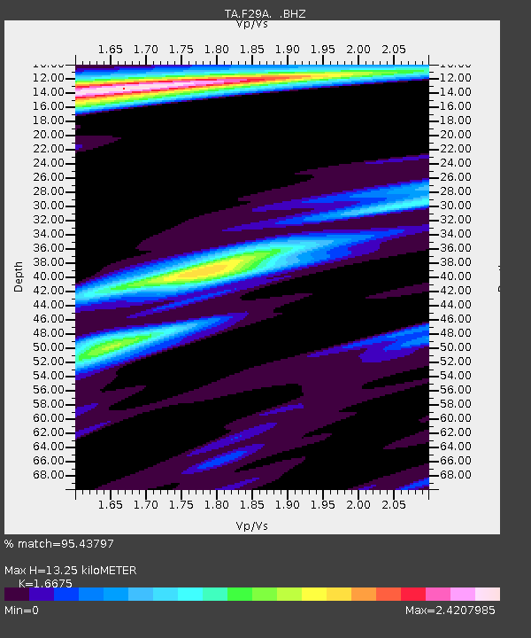
| Estimated Moho Depth: |
13.25 km |
| Estimated Crust Vp/Vs: |
1.67 |
| Assumed Crust Vp: |
6.53 km/s |
| Estimated Crust Vs: |
3.916 km/s |
| Estimated Crust Poisson's Ratio: |
0.22 |
|
| Radial Match: |
95.43797 % |
| Radial Bump: |
335 |
| Transverse Match: |
89.78112 % |
| Transverse Bump: |
400 |
| SOD ConfigId: |
395004 |
| Insert Time: |
2011-12-01 06:16:26.981 +0000 |
| GWidth: |
2.5 |
| Max Bumps: |
400 |
| Tol: |
0.001 |
|

Signal To Noise
| Channel | StoN | STA | LTA |
| TA:F29A: :BHZ:20110620T16:46:46.475002Z | 29.097628 | 2.6658333E-6 | 9.161686E-8 |
| TA:F29A: :BHN:20110620T16:46:46.475002Z | 4.431139 | 1.7959288E-6 | 4.0529736E-7 |
| TA:F29A: :BHE:20110620T16:46:46.475002Z | 5.7041 | 1.0906917E-6 | 1.9121188E-7 |
| Arrivals |
| Ps | 1.4 SECOND |
| PpPs | 5.2 SECOND |
| PsPs/PpSs | 6.6 SECOND |


