You are here: Home > Network List > TA - USArray Transportable Network (new EarthScope stations) Stations List
> Station N31A Bailey Ranch, Gibbon, NE, USA > Earthquake Result Viewer
N31A Bailey Ranch, Gibbon, NE, USA - Earthquake Result Viewer
| Earthquake location: |
Chile-Bolivia Border Region |
| Earthquake latitude/longitude: |
-21.7/-68.2 |
| Earthquake time(UTC): |
2011/06/20 (171) 16:36:01 GMT |
| Earthquake Depth: |
128 km |
| Earthquake Magnitude: |
6.0 MB, 6.5 MW, 6.5 MW |
| Earthquake Catalog/Contributor: |
WHDF/NEIC |
|
| Network: |
TA USArray Transportable Network (new EarthScope stations) |
| Station: |
N31A Bailey Ranch, Gibbon, NE, USA |
| Lat/Lon: |
40.82 N/98.95 W |
| Elevation: |
687 m |
|
| Distance: |
68.5 deg |
| Az: |
335.362 deg |
| Baz: |
149.279 deg |
| Ray Param: |
0.055955306 |
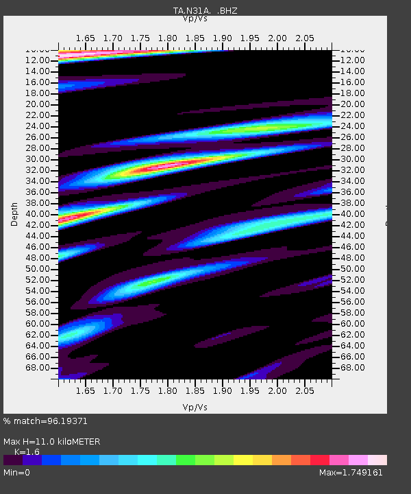
| Estimated Moho Depth: |
11.0 km |
| Estimated Crust Vp/Vs: |
1.60 |
| Assumed Crust Vp: |
6.53 km/s |
| Estimated Crust Vs: |
4.082 km/s |
| Estimated Crust Poisson's Ratio: |
0.18 |
|
| Radial Match: |
96.19371 % |
| Radial Bump: |
400 |
| Transverse Match: |
87.30508 % |
| Transverse Bump: |
400 |
| SOD ConfigId: |
395004 |
| Insert Time: |
2011-12-01 06:17:08.240 +0000 |
| GWidth: |
2.5 |
| Max Bumps: |
400 |
| Tol: |
0.001 |
|

Signal To Noise
| Channel | StoN | STA | LTA |
| TA:N31A: :BHZ:20110620T16:46:18.52499Z | 10.841117 | 3.2952337E-6 | 3.0395702E-7 |
| TA:N31A: :BHN:20110620T16:46:18.52499Z | 4.041319 | 2.331156E-6 | 5.7683053E-7 |
| TA:N31A: :BHE:20110620T16:46:18.52499Z | 3.4355645 | 1.4307022E-6 | 4.1643878E-7 |
| Arrivals |
| Ps | 1.1 SECOND |
| PpPs | 4.2 SECOND |
| PsPs/PpSs | 5.2 SECOND |


