You are here: Home > Network List > TA - USArray Transportable Network (new EarthScope stations) Stations List
> Station O31A Woollen Ranch, Alma, NE, USA > Earthquake Result Viewer
O31A Woollen Ranch, Alma, NE, USA - Earthquake Result Viewer
| Earthquake location: |
Chile-Bolivia Border Region |
| Earthquake latitude/longitude: |
-21.7/-68.2 |
| Earthquake time(UTC): |
2011/06/20 (171) 16:36:01 GMT |
| Earthquake Depth: |
128 km |
| Earthquake Magnitude: |
6.0 MB, 6.5 MW, 6.5 MW |
| Earthquake Catalog/Contributor: |
WHDF/NEIC |
|
| Network: |
TA USArray Transportable Network (new EarthScope stations) |
| Station: |
O31A Woollen Ranch, Alma, NE, USA |
| Lat/Lon: |
40.15 N/99.33 W |
| Elevation: |
631 m |
|
| Distance: |
68.0 deg |
| Az: |
334.729 deg |
| Baz: |
148.803 deg |
| Ray Param: |
0.056234065 |
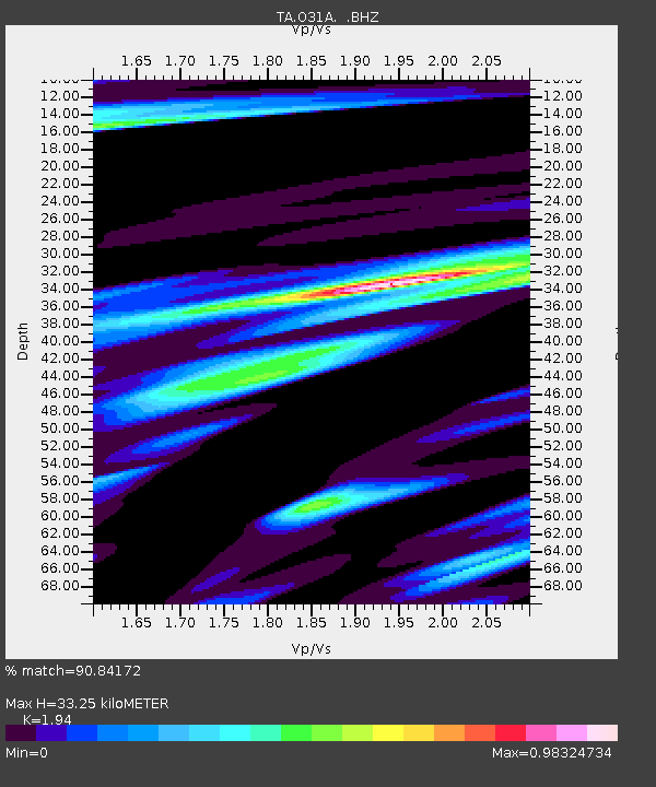
| Estimated Moho Depth: |
33.25 km |
| Estimated Crust Vp/Vs: |
1.94 |
| Assumed Crust Vp: |
6.53 km/s |
| Estimated Crust Vs: |
3.366 km/s |
| Estimated Crust Poisson's Ratio: |
0.32 |
|
| Radial Match: |
90.84172 % |
| Radial Bump: |
390 |
| Transverse Match: |
70.2393 % |
| Transverse Bump: |
400 |
| SOD ConfigId: |
395004 |
| Insert Time: |
2011-12-01 06:17:24.381 +0000 |
| GWidth: |
2.5 |
| Max Bumps: |
400 |
| Tol: |
0.001 |
|
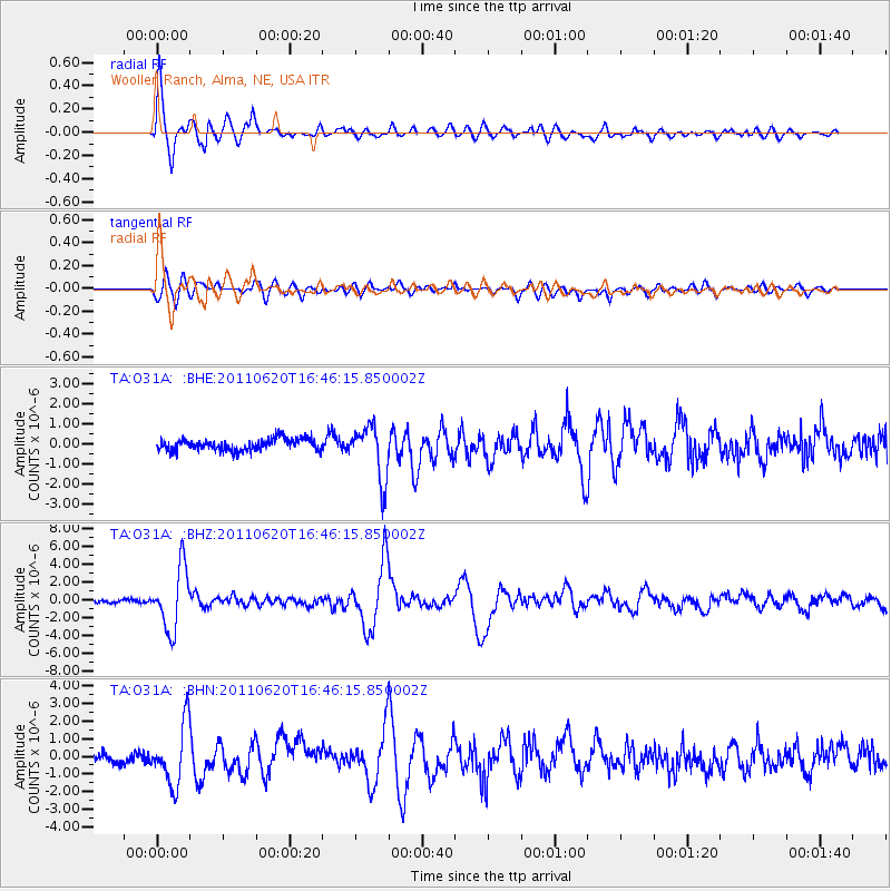
Signal To Noise
| Channel | StoN | STA | LTA |
| TA:O31A: :BHZ:20110620T16:46:15.850002Z | 24.055017 | 3.4432435E-6 | 1.4314034E-7 |
| TA:O31A: :BHN:20110620T16:46:15.850002Z | 5.880719 | 1.7111959E-6 | 2.909841E-7 |
| TA:O31A: :BHE:20110620T16:46:15.850002Z | 4.60091 | 1.3492032E-6 | 2.93247E-7 |
| Arrivals |
| Ps | 5.0 SECOND |
| PpPs | 14 SECOND |
| PsPs/PpSs | 19 SECOND |


