You are here: Home > Network List > CD - China Digital Seismograph Network Stations List
> Station WMQ Urumqi, Xinjiang Province, China > Earthquake Result Viewer
WMQ Urumqi, Xinjiang Province, China - Earthquake Result Viewer
| Earthquake location: |
Solomon Islands |
| Earthquake latitude/longitude: |
-5.7/154.1 |
| Earthquake time(UTC): |
1994/04/21 (111) 03:51:44 GMT |
| Earthquake Depth: |
30 km |
| Earthquake Magnitude: |
5.8 MB, 6.6 MS, 6.7 UNKNOWN, 6.6 MW |
| Earthquake Catalog/Contributor: |
WHDF/NEIC |
|
| Network: |
CD China Digital Seismograph Network |
| Station: |
WMQ Urumqi, Xinjiang Province, China |
| Lat/Lon: |
43.82 N/87.69 E |
| Elevation: |
903 m |
|
| Distance: |
77.3 deg |
| Az: |
317.16 deg |
| Baz: |
110.804 deg |
| Ray Param: |
0.05039801 |
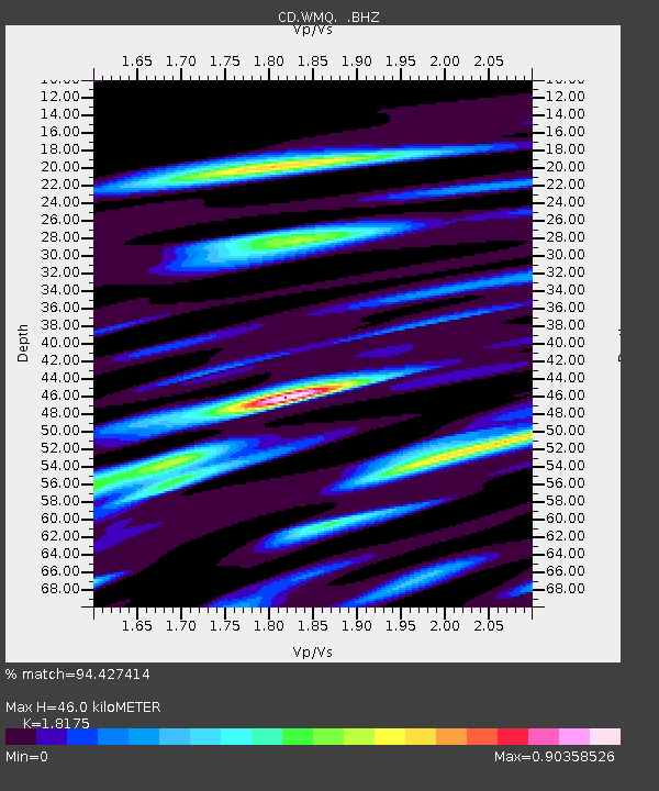
| Estimated Moho Depth: |
46.0 km |
| Estimated Crust Vp/Vs: |
1.82 |
| Assumed Crust Vp: |
6.242 km/s |
| Estimated Crust Vs: |
3.434 km/s |
| Estimated Crust Poisson's Ratio: |
0.28 |
|
| Radial Match: |
94.427414 % |
| Radial Bump: |
400 |
| Transverse Match: |
91.80404 % |
| Transverse Bump: |
400 |
| SOD ConfigId: |
4480 |
| Insert Time: |
2010-02-26 21:24:44.218 +0000 |
| GWidth: |
2.5 |
| Max Bumps: |
400 |
| Tol: |
0.001 |
|
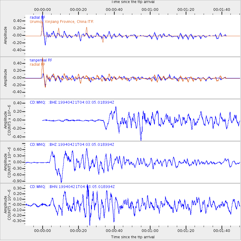
Signal To Noise
| Channel | StoN | STA | LTA |
| CD:WMQ: :BHZ:19940421T04:03:05.018994Z | 8.430931 | 9.9741285E-8 | 1.18304E-8 |
| CD:WMQ: :BHN:19940421T04:03:05.018994Z | 2.1999154 | 1.8190914E-8 | 8.268914E-9 |
| CD:WMQ: :BHE:19940421T04:03:05.018994Z | 3.9805448 | 3.3114272E-8 | 8.31903E-9 |
| Arrivals |
| Ps | 6.2 SECOND |
| PpPs | 20 SECOND |
| PsPs/PpSs | 26 SECOND |


