You are here: Home > Network List > TA - USArray Transportable Network (new EarthScope stations) Stations List
> Station V33A Lossen Ranch, Watonga, OK, USA > Earthquake Result Viewer
V33A Lossen Ranch, Watonga, OK, USA - Earthquake Result Viewer
| Earthquake location: |
Chile-Bolivia Border Region |
| Earthquake latitude/longitude: |
-21.7/-68.2 |
| Earthquake time(UTC): |
2011/06/20 (171) 16:36:01 GMT |
| Earthquake Depth: |
128 km |
| Earthquake Magnitude: |
6.0 MB, 6.5 MW, 6.5 MW |
| Earthquake Catalog/Contributor: |
WHDF/NEIC |
|
| Network: |
TA USArray Transportable Network (new EarthScope stations) |
| Station: |
V33A Lossen Ranch, Watonga, OK, USA |
| Lat/Lon: |
35.82 N/98.29 W |
| Elevation: |
420 m |
|
| Distance: |
63.9 deg |
| Az: |
333.045 deg |
| Baz: |
148.755 deg |
| Ray Param: |
0.05891289 |
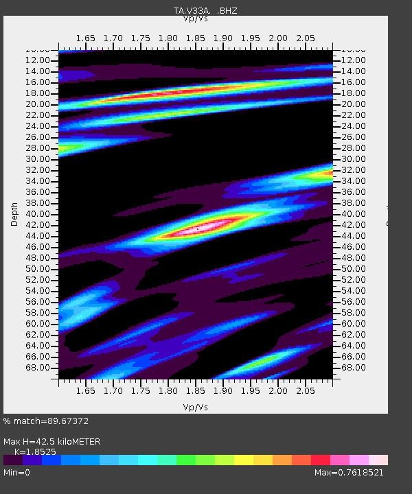
| Estimated Moho Depth: |
42.5 km |
| Estimated Crust Vp/Vs: |
1.85 |
| Assumed Crust Vp: |
6.315 km/s |
| Estimated Crust Vs: |
3.409 km/s |
| Estimated Crust Poisson's Ratio: |
0.29 |
|
| Radial Match: |
89.67372 % |
| Radial Bump: |
400 |
| Transverse Match: |
79.19533 % |
| Transverse Bump: |
400 |
| SOD ConfigId: |
395004 |
| Insert Time: |
2011-12-01 06:20:05.169 +0000 |
| GWidth: |
2.5 |
| Max Bumps: |
400 |
| Tol: |
0.001 |
|
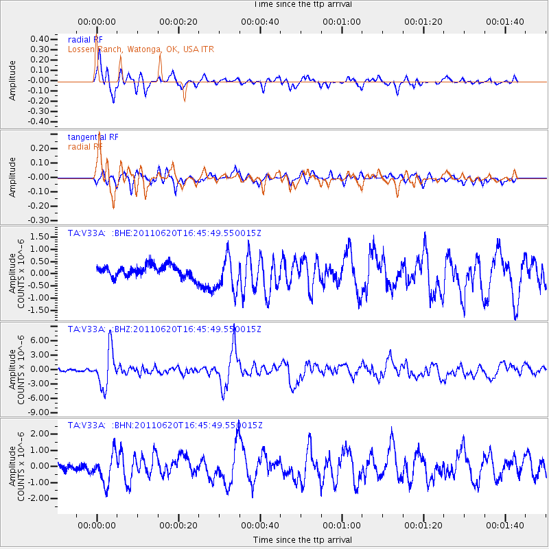
Signal To Noise
| Channel | StoN | STA | LTA |
| TA:V33A: :BHZ:20110620T16:45:49.550015Z | 18.053953 | 4.00193E-6 | 2.2166502E-7 |
| TA:V33A: :BHN:20110620T16:45:49.550015Z | 5.9895706 | 9.243863E-7 | 1.5433265E-7 |
| TA:V33A: :BHE:20110620T16:45:49.550015Z | 2.9499326 | 7.0786575E-7 | 2.3995997E-7 |
| Arrivals |
| Ps | 6.0 SECOND |
| PpPs | 18 SECOND |
| PsPs/PpSs | 24 SECOND |


