You are here: Home > Network List > CD - China Digital Seismograph Network Stations List
> Station WMQ Urumqi, Xinjiang Province, China > Earthquake Result Viewer
WMQ Urumqi, Xinjiang Province, China - Earthquake Result Viewer
| Earthquake location: |
Nicobar Islands, India Region |
| Earthquake latitude/longitude: |
7.6/94.3 |
| Earthquake time(UTC): |
1994/05/25 (145) 18:42:19 GMT |
| Earthquake Depth: |
24 km |
| Earthquake Magnitude: |
5.6 MB, 5.6 MS |
| Earthquake Catalog/Contributor: |
WHDF/NEIC |
|
| Network: |
CD China Digital Seismograph Network |
| Station: |
WMQ Urumqi, Xinjiang Province, China |
| Lat/Lon: |
43.82 N/87.69 E |
| Elevation: |
903 m |
|
| Distance: |
36.5 deg |
| Az: |
352.002 deg |
| Baz: |
169.015 deg |
| Ray Param: |
0.076590806 |
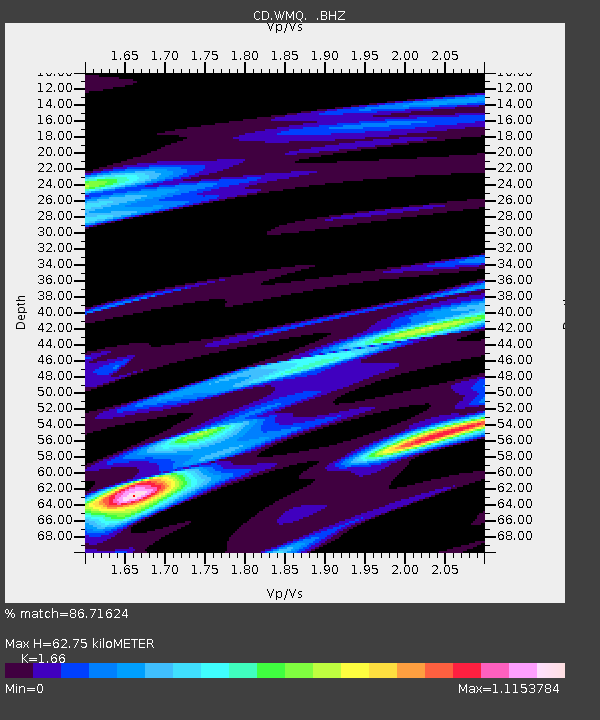
| Estimated Moho Depth: |
62.75 km |
| Estimated Crust Vp/Vs: |
1.66 |
| Assumed Crust Vp: |
6.242 km/s |
| Estimated Crust Vs: |
3.76 km/s |
| Estimated Crust Poisson's Ratio: |
0.22 |
|
| Radial Match: |
86.71624 % |
| Radial Bump: |
400 |
| Transverse Match: |
79.993996 % |
| Transverse Bump: |
400 |
| SOD ConfigId: |
4480 |
| Insert Time: |
2010-02-26 21:24:46.381 +0000 |
| GWidth: |
2.5 |
| Max Bumps: |
400 |
| Tol: |
0.001 |
|
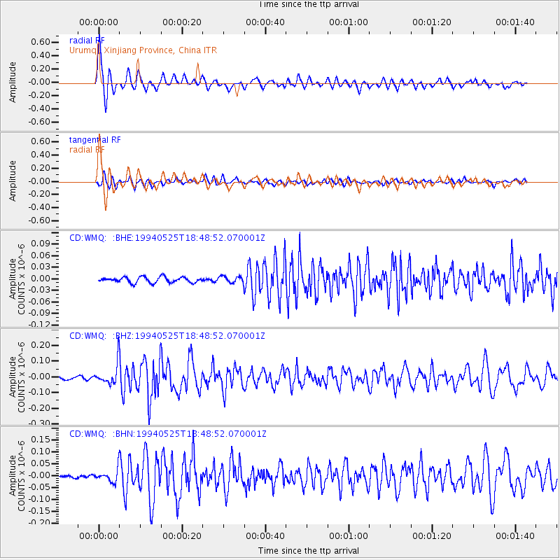
Signal To Noise
| Channel | StoN | STA | LTA |
| CD:WMQ: :BHZ:19940525T18:48:52.070001Z | 5.7953124 | 7.128862E-8 | 1.2301083E-8 |
| CD:WMQ: :BHN:19940525T18:48:52.070001Z | 3.9658458 | 2.8305077E-8 | 7.137211E-9 |
| CD:WMQ: :BHE:19940525T18:48:52.070001Z | 1.176301 | 8.368166E-9 | 7.1139663E-9 |
| Arrivals |
| Ps | 7.2 SECOND |
| PpPs | 25 SECOND |
| PsPs/PpSs | 32 SECOND |


