You are here: Home > Network List > TA - USArray Transportable Network (new EarthScope stations) Stations List
> Station X34A Smith Ranch, Marlow, OK, USA > Earthquake Result Viewer
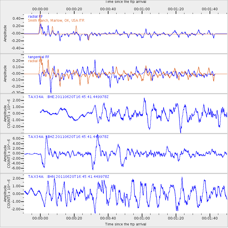
X34A Smith Ranch, Marlow, OK, USA - Earthquake Result Viewer

| Earthquake location: |
Chile-Bolivia Border Region |
| Earthquake latitude/longitude: |
-21.7/-68.2 |
| Earthquake time(UTC): |
2011/06/20 (171) 16:36:01 GMT |
| Earthquake Depth: |
128 km |
| Earthquake Magnitude: |
6.0 MB, 6.5 MW, 6.5 MW |
| Earthquake Catalog/Contributor: |
WHDF/NEIC |
|
| Network: |
TA USArray Transportable Network (new EarthScope stations) |
| Station: |
X34A Smith Ranch, Marlow, OK, USA |
| Lat/Lon: |
34.60 N/97.83 W |
| Elevation: |
364 m |
|
| Distance: |
62.7 deg |
| Az: |
332.695 deg |
| Baz: |
148.858 deg |
| Ray Param: |
0.05971283 |
| Estimated Moho Depth: |
48.75 km |
| Estimated Crust Vp/Vs: |
1.60 |
| Assumed Crust Vp: |
6.426 km/s |
| Estimated Crust Vs: |
4.016 km/s |
| Estimated Crust Poisson's Ratio: |
0.18 |
|
| Radial Match: |
85.02052 % |
| Radial Bump: |
400 |
| Transverse Match: |
86.2999 % |
| Transverse Bump: |
400 |
| SOD ConfigId: |
395004 |
| Insert Time: |
2011-12-01 06:20:30.006 +0000 |
| GWidth: |
2.5 |
| Max Bumps: |
400 |
| Tol: |
0.001 |
|
Signal To Noise
| Channel | StoN | STA | LTA |
| TA:X34A: :BHZ:20110620T16:45:41.449978Z | 21.395582 | 3.774222E-6 | 1.7640194E-7 |
| TA:X34A: :BHN:20110620T16:45:41.449978Z | 2.022211 | 8.7847735E-7 | 4.344143E-7 |
| TA:X34A: :BHE:20110620T16:45:41.449978Z | 1.4992186 | 7.7498083E-7 | 5.169232E-7 |
| Arrivals |
| Ps | 4.8 SECOND |
| PpPs | 19 SECOND |
| PsPs/PpSs | 24 SECOND |


