You are here: Home > Network List > TA - USArray Transportable Network (new EarthScope stations) Stations List
> Station Z33A Whitaker Ranch, Olney, TX, USA > Earthquake Result Viewer
Z33A Whitaker Ranch, Olney, TX, USA - Earthquake Result Viewer
| Earthquake location: |
Chile-Bolivia Border Region |
| Earthquake latitude/longitude: |
-21.7/-68.2 |
| Earthquake time(UTC): |
2011/06/20 (171) 16:36:01 GMT |
| Earthquake Depth: |
128 km |
| Earthquake Magnitude: |
6.0 MB, 6.5 MW, 6.5 MW |
| Earthquake Catalog/Contributor: |
WHDF/NEIC |
|
| Network: |
TA USArray Transportable Network (new EarthScope stations) |
| Station: |
Z33A Whitaker Ranch, Olney, TX, USA |
| Lat/Lon: |
33.29 N/98.76 W |
| Elevation: |
362 m |
|
| Distance: |
62.0 deg |
| Az: |
331.171 deg |
| Baz: |
147.632 deg |
| Ray Param: |
0.060167428 |
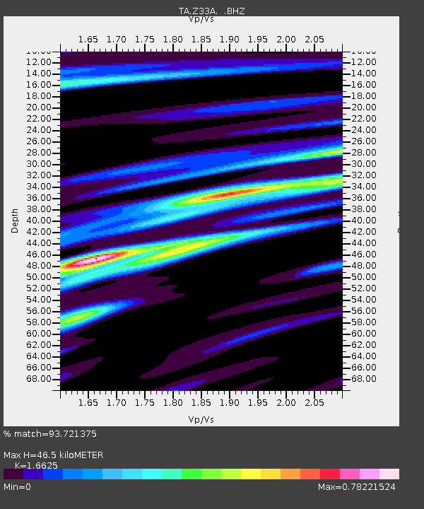
| Estimated Moho Depth: |
46.5 km |
| Estimated Crust Vp/Vs: |
1.66 |
| Assumed Crust Vp: |
6.426 km/s |
| Estimated Crust Vs: |
3.865 km/s |
| Estimated Crust Poisson's Ratio: |
0.22 |
|
| Radial Match: |
93.721375 % |
| Radial Bump: |
356 |
| Transverse Match: |
86.44491 % |
| Transverse Bump: |
400 |
| SOD ConfigId: |
395004 |
| Insert Time: |
2011-12-01 06:20:32.901 +0000 |
| GWidth: |
2.5 |
| Max Bumps: |
400 |
| Tol: |
0.001 |
|

Signal To Noise
| Channel | StoN | STA | LTA |
| TA:Z33A: :BHZ:20110620T16:45:36.750027Z | 32.342247 | 3.4095972E-6 | 1.05422394E-7 |
| TA:Z33A: :BHN:20110620T16:45:36.750027Z | 13.902782 | 1.3197445E-6 | 9.492664E-8 |
| TA:Z33A: :BHE:20110620T16:45:36.750027Z | 6.289386 | 9.39497E-7 | 1.4937818E-7 |
| Arrivals |
| Ps | 5.0 SECOND |
| PpPs | 18 SECOND |
| PsPs/PpSs | 23 SECOND |


