You are here: Home > Network List > CD - China Digital Seismograph Network Stations List
> Station WMQ Urumqi, Xinjiang Province, China > Earthquake Result Viewer
WMQ Urumqi, Xinjiang Province, China - Earthquake Result Viewer
| Earthquake location: |
Taiwan Region |
| Earthquake latitude/longitude: |
24.0/122.6 |
| Earthquake time(UTC): |
1994/05/23 (143) 15:16:58 GMT |
| Earthquake Depth: |
33 km |
| Earthquake Magnitude: |
5.9 MB, 5.7 MS, 6.0 UNKNOWN, 5.9 MW |
| Earthquake Catalog/Contributor: |
WHDF/NEIC |
|
| Network: |
CD China Digital Seismograph Network |
| Station: |
WMQ Urumqi, Xinjiang Province, China |
| Lat/Lon: |
43.82 N/87.69 E |
| Elevation: |
903 m |
|
| Distance: |
34.7 deg |
| Az: |
313.314 deg |
| Baz: |
113.221 deg |
| Ray Param: |
0.07756612 |
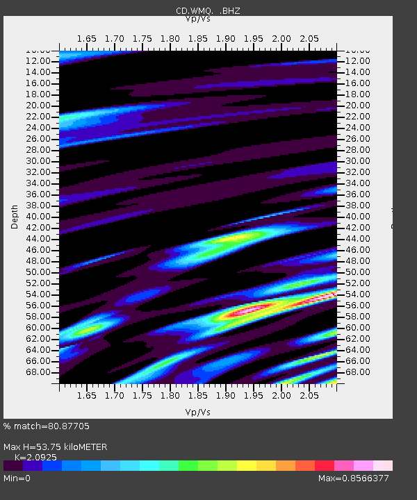
| Estimated Moho Depth: |
53.75 km |
| Estimated Crust Vp/Vs: |
2.09 |
| Assumed Crust Vp: |
6.242 km/s |
| Estimated Crust Vs: |
2.983 km/s |
| Estimated Crust Poisson's Ratio: |
0.35 |
|
| Radial Match: |
80.87705 % |
| Radial Bump: |
400 |
| Transverse Match: |
77.0463 % |
| Transverse Bump: |
400 |
| SOD ConfigId: |
4480 |
| Insert Time: |
2010-02-26 21:24:47.629 +0000 |
| GWidth: |
2.5 |
| Max Bumps: |
400 |
| Tol: |
0.001 |
|

Signal To Noise
| Channel | StoN | STA | LTA |
| CD:WMQ: :BHZ:19940523T15:23:14.319012Z | 27.867525 | 2.2310111E-7 | 8.005774E-9 |
| CD:WMQ: :BHN:19940523T15:23:14.319012Z | 8.708037 | 4.0342826E-8 | 4.6328266E-9 |
| CD:WMQ: :BHE:19940523T15:23:14.319012Z | 16.734373 | 9.531111E-8 | 5.6955294E-9 |
| Arrivals |
| Ps | 10.0 SECOND |
| PpPs | 25 SECOND |
| PsPs/PpSs | 35 SECOND |


