You are here: Home > Network List > TA - USArray Transportable Network (new EarthScope stations) Stations List
> Station 134A White-Moore Ranch, Lipan, TX, USA > Earthquake Result Viewer
134A White-Moore Ranch, Lipan, TX, USA - Earthquake Result Viewer
| Earthquake location: |
Chile-Bolivia Border Region |
| Earthquake latitude/longitude: |
-21.7/-68.2 |
| Earthquake time(UTC): |
2011/06/20 (171) 16:36:01 GMT |
| Earthquake Depth: |
128 km |
| Earthquake Magnitude: |
6.0 MB, 6.5 MW, 6.5 MW |
| Earthquake Catalog/Contributor: |
WHDF/NEIC |
|
| Network: |
TA USArray Transportable Network (new EarthScope stations) |
| Station: |
134A White-Moore Ranch, Lipan, TX, USA |
| Lat/Lon: |
32.57 N/98.08 W |
| Elevation: |
297 m |
|
| Distance: |
61.0 deg |
| Az: |
331.295 deg |
| Baz: |
148.062 deg |
| Ray Param: |
0.0607548 |
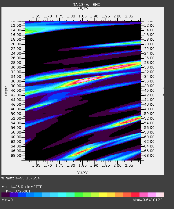
| Estimated Moho Depth: |
35.0 km |
| Estimated Crust Vp/Vs: |
1.87 |
| Assumed Crust Vp: |
6.426 km/s |
| Estimated Crust Vs: |
3.432 km/s |
| Estimated Crust Poisson's Ratio: |
0.30 |
|
| Radial Match: |
95.337654 % |
| Radial Bump: |
400 |
| Transverse Match: |
81.00056 % |
| Transverse Bump: |
400 |
| SOD ConfigId: |
395004 |
| Insert Time: |
2011-12-01 06:22:14.142 +0000 |
| GWidth: |
2.5 |
| Max Bumps: |
400 |
| Tol: |
0.001 |
|

Signal To Noise
| Channel | StoN | STA | LTA |
| TA:134A: :BHZ:20110620T16:45:30.675015Z | 36.60283 | 3.5035857E-6 | 9.571898E-8 |
| TA:134A: :BHN:20110620T16:45:30.675015Z | 12.369663 | 1.6712894E-6 | 1.3511196E-7 |
| TA:134A: :BHE:20110620T16:45:30.675015Z | 5.145997 | 1.2170641E-6 | 2.3650696E-7 |
| Arrivals |
| Ps | 5.0 SECOND |
| PpPs | 15 SECOND |
| PsPs/PpSs | 20 SECOND |


