You are here: Home > Network List > CD - China Digital Seismograph Network Stations List
> Station WMQ Urumqi, Xinjiang Province, China > Earthquake Result Viewer
WMQ Urumqi, Xinjiang Province, China - Earthquake Result Viewer

| Earthquake location: |
Kuril Islands |
| Earthquake latitude/longitude: |
43.5/147.5 |
| Earthquake time(UTC): |
1994/10/05 (278) 20:37:31 GMT |
| Earthquake Depth: |
33 km |
| Earthquake Magnitude: |
5.7 MB, 5.9 MS, 5.9 UNKNOWN, 5.9 MW |
| Earthquake Catalog/Contributor: |
WHDF/NEIC |
|
| Network: |
CD China Digital Seismograph Network |
| Station: |
WMQ Urumqi, Xinjiang Province, China |
| Lat/Lon: |
43.82 N/87.69 E |
| Elevation: |
903 m |
|
| Distance: |
42.4 deg |
| Az: |
291.911 deg |
| Baz: |
68.755 deg |
| Ray Param: |
0.07314604 |
| Estimated Moho Depth: |
65.0 km |
| Estimated Crust Vp/Vs: |
1.60 |
| Assumed Crust Vp: |
6.242 km/s |
| Estimated Crust Vs: |
3.901 km/s |
| Estimated Crust Poisson's Ratio: |
0.18 |
|
| Radial Match: |
91.85448 % |
| Radial Bump: |
400 |
| Transverse Match: |
89.63983 % |
| Transverse Bump: |
400 |
| SOD ConfigId: |
4480 |
| Insert Time: |
2010-02-26 21:24:49.344 +0000 |
| GWidth: |
2.5 |
| Max Bumps: |
400 |
| Tol: |
0.001 |
|
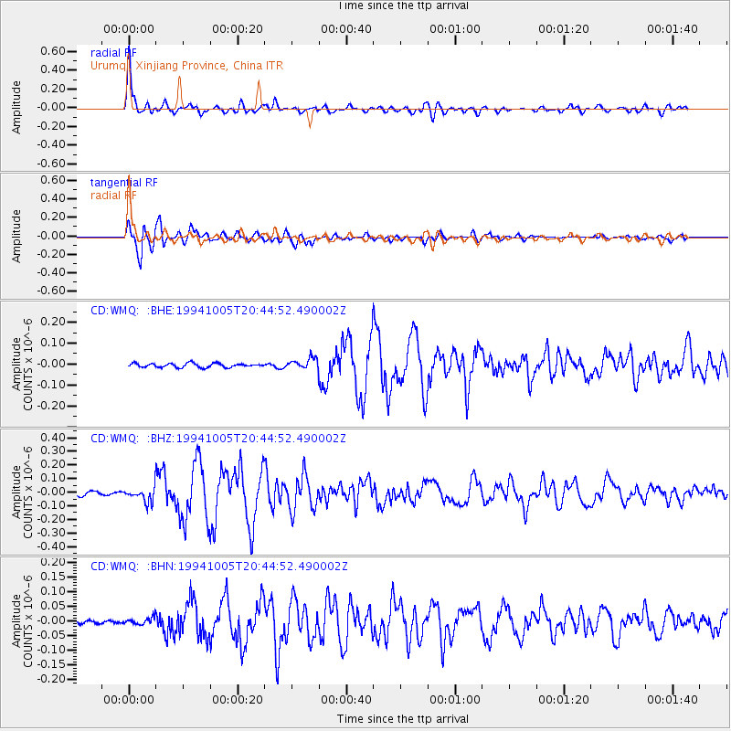
Signal To Noise
| Channel | StoN | STA | LTA |
| CD:WMQ: :BHZ:19941005T20:44:52.490002Z | 3.3276088 | 4.984674E-8 | 1.4979747E-8 |
| CD:WMQ: :BHN:19941005T20:44:52.490002Z | 1.4904091 | 1.1364587E-8 | 7.625146E-9 |
| CD:WMQ: :BHE:19941005T20:44:52.490002Z | 2.7123635 | 2.6043017E-8 | 9.601595E-9 |
| Arrivals |
| Ps | 6.7 SECOND |
| PpPs | 25 SECOND |
| PsPs/PpSs | 32 SECOND |


