You are here: Home > Network List > TA - USArray Transportable Network (new EarthScope stations) Stations List
> Station 832A Faith Ranch, Carrizo Springs, TX, USA > Earthquake Result Viewer
832A Faith Ranch, Carrizo Springs, TX, USA - Earthquake Result Viewer

| Earthquake location: |
Chile-Bolivia Border Region |
| Earthquake latitude/longitude: |
-21.7/-68.2 |
| Earthquake time(UTC): |
2011/06/20 (171) 16:36:01 GMT |
| Earthquake Depth: |
128 km |
| Earthquake Magnitude: |
6.0 MB, 6.5 MW, 6.5 MW |
| Earthquake Catalog/Contributor: |
WHDF/NEIC |
|
| Network: |
TA USArray Transportable Network (new EarthScope stations) |
| Station: |
832A Faith Ranch, Carrizo Springs, TX, USA |
| Lat/Lon: |
28.28 N/99.97 W |
| Elevation: |
238 m |
|
| Distance: |
58.4 deg |
| Az: |
326.983 deg |
| Baz: |
144.93 deg |
| Ray Param: |
0.062488064 |
| Estimated Moho Depth: |
30.75 km |
| Estimated Crust Vp/Vs: |
1.80 |
| Assumed Crust Vp: |
6.347 km/s |
| Estimated Crust Vs: |
3.521 km/s |
| Estimated Crust Poisson's Ratio: |
0.28 |
|
| Radial Match: |
96.96786 % |
| Radial Bump: |
252 |
| Transverse Match: |
88.82257 % |
| Transverse Bump: |
400 |
| SOD ConfigId: |
395004 |
| Insert Time: |
2011-12-01 06:22:51.988 +0000 |
| GWidth: |
2.5 |
| Max Bumps: |
400 |
| Tol: |
0.001 |
|
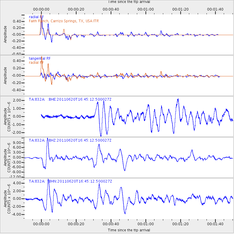
Signal To Noise
| Channel | StoN | STA | LTA |
| TA:832A: :BHZ:20110620T16:45:12.500027Z | 41.35235 | 5.4821335E-6 | 1.3257129E-7 |
| TA:832A: :BHN:20110620T16:45:12.500027Z | 15.440181 | 2.3129503E-6 | 1.4980071E-7 |
| TA:832A: :BHE:20110620T16:45:12.500027Z | 11.931714 | 1.2506712E-6 | 1.0481907E-7 |
| Arrivals |
| Ps | 4.1 SECOND |
| PpPs | 13 SECOND |
| PsPs/PpSs | 17 SECOND |


