You are here: Home > Network List > TA - USArray Transportable Network (new EarthScope stations) Stations List
> Station 337A Centerville, TX, USA > Earthquake Result Viewer
337A Centerville, TX, USA - Earthquake Result Viewer
| Earthquake location: |
Chile-Bolivia Border Region |
| Earthquake latitude/longitude: |
-21.7/-68.2 |
| Earthquake time(UTC): |
2011/06/20 (171) 16:36:01 GMT |
| Earthquake Depth: |
128 km |
| Earthquake Magnitude: |
6.0 MB, 6.5 MW, 6.5 MW |
| Earthquake Catalog/Contributor: |
WHDF/NEIC |
|
| Network: |
TA USArray Transportable Network (new EarthScope stations) |
| Station: |
337A Centerville, TX, USA |
| Lat/Lon: |
31.32 N/95.89 W |
| Elevation: |
150 m |
|
| Distance: |
59.0 deg |
| Az: |
332.392 deg |
| Baz: |
149.765 deg |
| Ray Param: |
0.062078018 |
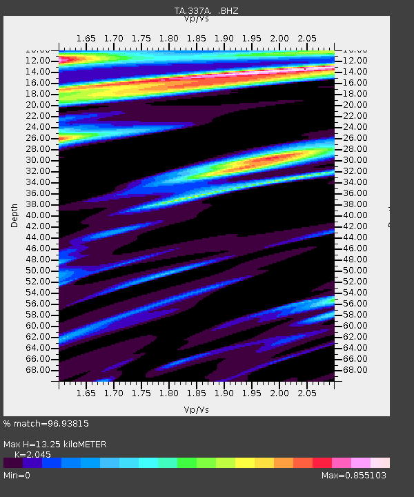
| Estimated Moho Depth: |
13.25 km |
| Estimated Crust Vp/Vs: |
2.05 |
| Assumed Crust Vp: |
5.738 km/s |
| Estimated Crust Vs: |
2.806 km/s |
| Estimated Crust Poisson's Ratio: |
0.34 |
|
| Radial Match: |
96.93815 % |
| Radial Bump: |
362 |
| Transverse Match: |
92.557846 % |
| Transverse Bump: |
395 |
| SOD ConfigId: |
395004 |
| Insert Time: |
2011-12-01 06:24:37.072 +0000 |
| GWidth: |
2.5 |
| Max Bumps: |
400 |
| Tol: |
0.001 |
|

Signal To Noise
| Channel | StoN | STA | LTA |
| TA:337A: :BHZ:20110620T16:45:16.800015Z | 28.171986 | 6.2502386E-6 | 2.2186006E-7 |
| TA:337A: :BHN:20110620T16:45:16.800015Z | 6.2700906 | 1.5982628E-6 | 2.5490266E-7 |
| TA:337A: :BHE:20110620T16:45:16.800015Z | 3.5437183 | 8.356304E-7 | 2.3580608E-7 |
| Arrivals |
| Ps | 2.5 SECOND |
| PpPs | 6.8 SECOND |
| PsPs/PpSs | 9.3 SECOND |


