You are here: Home > Network List > TA - USArray Transportable Network (new EarthScope stations) Stations List
> Station 339A Huntington, TX, USA > Earthquake Result Viewer
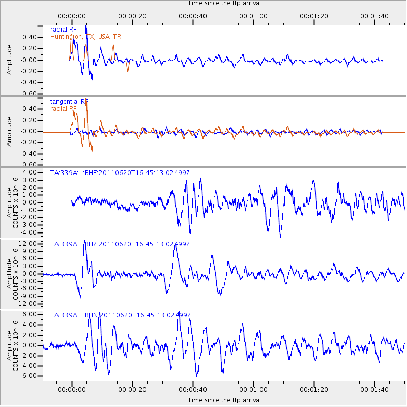
339A Huntington, TX, USA - Earthquake Result Viewer
*The percent match for this event was below the threshold and hence no stack was calculated.
| Earthquake location: |
Chile-Bolivia Border Region |
| Earthquake latitude/longitude: |
-21.7/-68.2 |
| Earthquake time(UTC): |
2011/06/20 (171) 16:36:01 GMT |
| Earthquake Depth: |
128 km |
| Earthquake Magnitude: |
6.0 MB, 6.5 MW, 6.5 MW |
| Earthquake Catalog/Contributor: |
WHDF/NEIC |
|
| Network: |
TA USArray Transportable Network (new EarthScope stations) |
| Station: |
339A Huntington, TX, USA |
| Lat/Lon: |
31.33 N/94.56 W |
| Elevation: |
82 m |
|
| Distance: |
58.5 deg |
| Az: |
333.56 deg |
| Baz: |
151.059 deg |
| Ray Param: |
$rayparam |
*The percent match for this event was below the threshold and hence was not used in the summary stack. |
|
| Radial Match: |
95.02968 % |
| Radial Bump: |
355 |
| Transverse Match: |
71.18581 % |
| Transverse Bump: |
400 |
| SOD ConfigId: |
395004 |
| Insert Time: |
2011-12-01 06:25:01.848 +0000 |
| GWidth: |
2.5 |
| Max Bumps: |
400 |
| Tol: |
0.001 |
|
Signal To Noise
| Channel | StoN | STA | LTA |
| TA:339A: :BHZ:20110620T16:45:13.02499Z | 30.47767 | 6.1457304E-6 | 2.0164698E-7 |
| TA:339A: :BHN:20110620T16:45:13.02499Z | 3.3812017 | 1.3917802E-6 | 4.1162292E-7 |
| TA:339A: :BHE:20110620T16:45:13.02499Z | 2.020933 | 8.9610694E-7 | 4.434125E-7 |
| Arrivals |
| Ps | |
| PpPs | |
| PsPs/PpSs | |


