You are here: Home > Network List > TA - USArray Transportable Network (new EarthScope stations) Stations List
> Station 437A Phaontom Ranch, North Zulch, TX, USA > Earthquake Result Viewer
437A Phaontom Ranch, North Zulch, TX, USA - Earthquake Result Viewer
| Earthquake location: |
Chile-Bolivia Border Region |
| Earthquake latitude/longitude: |
-21.7/-68.2 |
| Earthquake time(UTC): |
2011/06/20 (171) 16:36:01 GMT |
| Earthquake Depth: |
128 km |
| Earthquake Magnitude: |
6.0 MB, 6.5 MW, 6.5 MW |
| Earthquake Catalog/Contributor: |
WHDF/NEIC |
|
| Network: |
TA USArray Transportable Network (new EarthScope stations) |
| Station: |
437A Phaontom Ranch, North Zulch, TX, USA |
| Lat/Lon: |
30.83 N/96.14 W |
| Elevation: |
95 m |
|
| Distance: |
58.7 deg |
| Az: |
331.887 deg |
| Baz: |
149.374 deg |
| Ray Param: |
0.06228034 |
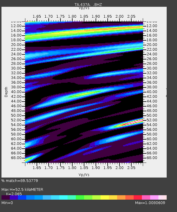
| Estimated Moho Depth: |
52.5 km |
| Estimated Crust Vp/Vs: |
2.07 |
| Assumed Crust Vp: |
6.347 km/s |
| Estimated Crust Vs: |
3.074 km/s |
| Estimated Crust Poisson's Ratio: |
0.35 |
|
| Radial Match: |
89.53779 % |
| Radial Bump: |
400 |
| Transverse Match: |
79.33406 % |
| Transverse Bump: |
400 |
| SOD ConfigId: |
395004 |
| Insert Time: |
2011-12-01 06:25:04.496 +0000 |
| GWidth: |
2.5 |
| Max Bumps: |
400 |
| Tol: |
0.001 |
|
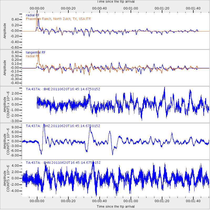
Signal To Noise
| Channel | StoN | STA | LTA |
| TA:437A: :BHZ:20110620T16:45:14.675015Z | 15.814285 | 5.4728625E-6 | 3.460708E-7 |
| TA:437A: :BHN:20110620T16:45:14.675015Z | 1.7172226 | 1.97824E-6 | 1.1519998E-6 |
| TA:437A: :BHE:20110620T16:45:14.675015Z | 1.6421884 | 9.0252735E-7 | 5.495882E-7 |
| Arrivals |
| Ps | 9.2 SECOND |
| PpPs | 24 SECOND |
| PsPs/PpSs | 34 SECOND |


