You are here: Home > Network List > TA - USArray Transportable Network (new EarthScope stations) Stations List
> Station 239A Gary, TX, USA > Earthquake Result Viewer
239A Gary, TX, USA - Earthquake Result Viewer

| Earthquake location: |
Chile-Bolivia Border Region |
| Earthquake latitude/longitude: |
-21.7/-68.2 |
| Earthquake time(UTC): |
2011/06/20 (171) 16:36:01 GMT |
| Earthquake Depth: |
128 km |
| Earthquake Magnitude: |
6.0 MB, 6.5 MW, 6.5 MW |
| Earthquake Catalog/Contributor: |
WHDF/NEIC |
|
| Network: |
TA USArray Transportable Network (new EarthScope stations) |
| Station: |
239A Gary, TX, USA |
| Lat/Lon: |
32.02 N/94.47 W |
| Elevation: |
100 m |
|
| Distance: |
59.0 deg |
| Az: |
334.019 deg |
| Baz: |
151.342 deg |
| Ray Param: |
0.062067326 |
| Estimated Moho Depth: |
10.5 km |
| Estimated Crust Vp/Vs: |
1.88 |
| Assumed Crust Vp: |
6.245 km/s |
| Estimated Crust Vs: |
3.317 km/s |
| Estimated Crust Poisson's Ratio: |
0.30 |
|
| Radial Match: |
96.561424 % |
| Radial Bump: |
357 |
| Transverse Match: |
92.25274 % |
| Transverse Bump: |
400 |
| SOD ConfigId: |
395004 |
| Insert Time: |
2011-12-01 06:25:30.187 +0000 |
| GWidth: |
2.5 |
| Max Bumps: |
400 |
| Tol: |
0.001 |
|
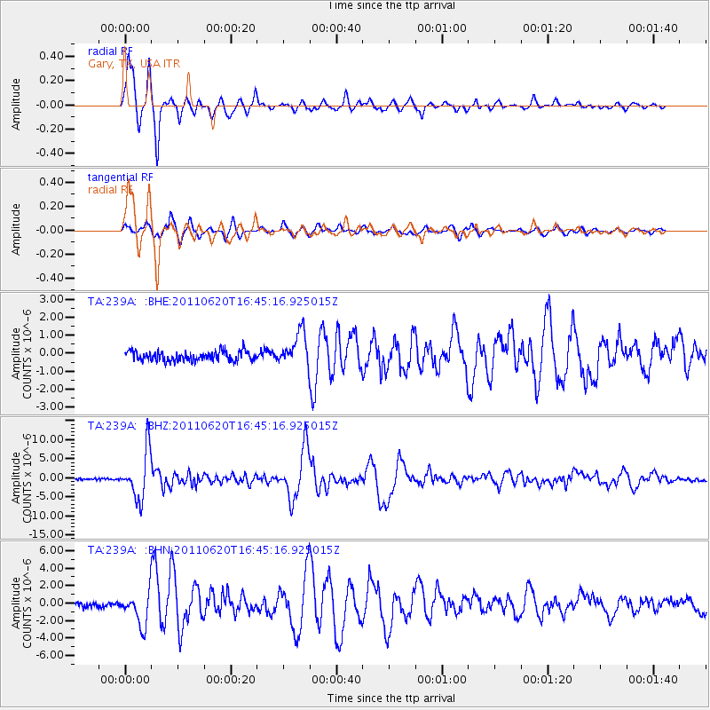
Signal To Noise
| Channel | StoN | STA | LTA |
| TA:239A: :BHZ:20110620T16:45:16.925015Z | 41.552505 | 6.325775E-6 | 1.522357E-7 |
| TA:239A: :BHN:20110620T16:45:16.925015Z | 6.027726 | 1.9127572E-6 | 3.1732648E-7 |
| TA:239A: :BHE:20110620T16:45:16.925015Z | 3.6295598 | 9.669193E-7 | 2.6640126E-7 |
| Arrivals |
| Ps | 1.5 SECOND |
| PpPs | 4.6 SECOND |
| PsPs/PpSs | 6.2 SECOND |


