You are here: Home > Network List > TA - USArray Transportable Network (new EarthScope stations) Stations List
> Station V35A Meyer Ranch, Chandler, OK, USA > Earthquake Result Viewer
V35A Meyer Ranch, Chandler, OK, USA - Earthquake Result Viewer
| Earthquake location: |
Chile-Bolivia Border Region |
| Earthquake latitude/longitude: |
-21.7/-68.2 |
| Earthquake time(UTC): |
2011/06/20 (171) 16:36:01 GMT |
| Earthquake Depth: |
128 km |
| Earthquake Magnitude: |
6.0 MB, 6.5 MW, 6.5 MW |
| Earthquake Catalog/Contributor: |
WHDF/NEIC |
|
| Network: |
TA USArray Transportable Network (new EarthScope stations) |
| Station: |
V35A Meyer Ranch, Chandler, OK, USA |
| Lat/Lon: |
35.76 N/96.84 W |
| Elevation: |
280 m |
|
| Distance: |
63.2 deg |
| Az: |
334.144 deg |
| Baz: |
150.087 deg |
| Ray Param: |
0.05933565 |
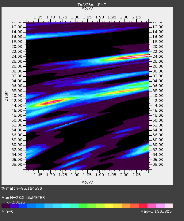
| Estimated Moho Depth: |
23.5 km |
| Estimated Crust Vp/Vs: |
2.08 |
| Assumed Crust Vp: |
6.426 km/s |
| Estimated Crust Vs: |
3.086 km/s |
| Estimated Crust Poisson's Ratio: |
0.35 |
|
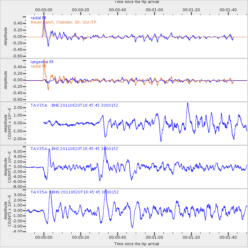
| Radial Match: |
95.164536 % |
| Radial Bump: |
366 |
| Transverse Match: |
83.36308 % |
| Transverse Bump: |
400 |
| SOD ConfigId: |
395004 |
| Insert Time: |
2011-12-01 06:25:54.757 +0000 |
| GWidth: |
2.5 |
| Max Bumps: |
400 |
| Tol: |
0.001 |
|
Signal To Noise
| Channel | StoN | STA | LTA |
| TA:V35A: :BHZ:20110620T16:45:45.300015Z | 36.82829 | 3.4840416E-6 | 9.460232E-8 |
| TA:V35A: :BHN:20110620T16:45:45.300015Z | 13.5897255 | 1.940968E-6 | 1.4282614E-7 |
| TA:V35A: :BHE:20110620T16:45:45.300015Z | 5.6181703 | 8.5636844E-7 | 1.5242836E-7 |
| Arrivals |
| Ps | 4.1 SECOND |
| PpPs | 11 SECOND |
| PsPs/PpSs | 15 SECOND |


