You are here: Home > Network List > TA - USArray Transportable Network (new EarthScope stations) Stations List
> Station X36A Centrahoma, OK, USA > Earthquake Result Viewer
X36A Centrahoma, OK, USA - Earthquake Result Viewer
| Earthquake location: |
Chile-Bolivia Border Region |
| Earthquake latitude/longitude: |
-21.7/-68.2 |
| Earthquake time(UTC): |
2011/06/20 (171) 16:36:01 GMT |
| Earthquake Depth: |
128 km |
| Earthquake Magnitude: |
6.0 MB, 6.5 MW, 6.5 MW |
| Earthquake Catalog/Contributor: |
WHDF/NEIC |
|
| Network: |
TA USArray Transportable Network (new EarthScope stations) |
| Station: |
X36A Centrahoma, OK, USA |
| Lat/Lon: |
34.57 N/96.35 W |
| Elevation: |
211 m |
|
| Distance: |
62.0 deg |
| Az: |
333.866 deg |
| Baz: |
150.238 deg |
| Ray Param: |
0.060127515 |
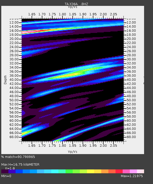
| Estimated Moho Depth: |
16.75 km |
| Estimated Crust Vp/Vs: |
1.60 |
| Assumed Crust Vp: |
6.426 km/s |
| Estimated Crust Vs: |
4.016 km/s |
| Estimated Crust Poisson's Ratio: |
0.18 |
|
| Radial Match: |
90.798965 % |
| Radial Bump: |
400 |
| Transverse Match: |
89.00862 % |
| Transverse Bump: |
400 |
| SOD ConfigId: |
395004 |
| Insert Time: |
2011-12-01 06:26:58.877 +0000 |
| GWidth: |
2.5 |
| Max Bumps: |
400 |
| Tol: |
0.001 |
|

Signal To Noise
| Channel | StoN | STA | LTA |
| TA:X36A: :BHZ:20110620T16:45:37.175015Z | 20.80854 | 3.0720573E-6 | 1.4763445E-7 |
| TA:X36A: :BHN:20110620T16:45:37.175015Z | 7.2751794 | 1.0470546E-6 | 1.4392148E-7 |
| TA:X36A: :BHE:20110620T16:45:37.175015Z | 2.9414725 | 5.234768E-7 | 1.7796418E-7 |
| Arrivals |
| Ps | 1.6 SECOND |
| PpPs | 6.5 SECOND |
| PsPs/PpSs | 8.1 SECOND |


