You are here: Home > Network List > TA - USArray Transportable Network (new EarthScope stations) Stations List
> Station Y36A Durant, OK, USA > Earthquake Result Viewer
Y36A Durant, OK, USA - Earthquake Result Viewer

| Earthquake location: |
Chile-Bolivia Border Region |
| Earthquake latitude/longitude: |
-21.7/-68.2 |
| Earthquake time(UTC): |
2011/06/20 (171) 16:36:01 GMT |
| Earthquake Depth: |
128 km |
| Earthquake Magnitude: |
6.0 MB, 6.5 MW, 6.5 MW |
| Earthquake Catalog/Contributor: |
WHDF/NEIC |
|
| Network: |
TA USArray Transportable Network (new EarthScope stations) |
| Station: |
Y36A Durant, OK, USA |
| Lat/Lon: |
33.90 N/96.28 W |
| Elevation: |
186 m |
|
| Distance: |
61.4 deg |
| Az: |
333.543 deg |
| Baz: |
150.123 deg |
| Ray Param: |
0.06052656 |
| Estimated Moho Depth: |
37.5 km |
| Estimated Crust Vp/Vs: |
2.01 |
| Assumed Crust Vp: |
6.38 km/s |
| Estimated Crust Vs: |
3.178 km/s |
| Estimated Crust Poisson's Ratio: |
0.33 |
|
| Radial Match: |
87.83542 % |
| Radial Bump: |
400 |
| Transverse Match: |
82.31228 % |
| Transverse Bump: |
400 |
| SOD ConfigId: |
395004 |
| Insert Time: |
2011-12-01 06:27:37.931 +0000 |
| GWidth: |
2.5 |
| Max Bumps: |
400 |
| Tol: |
0.001 |
|
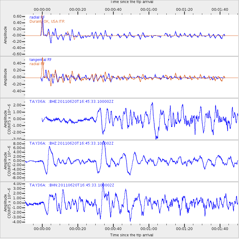
Signal To Noise
| Channel | StoN | STA | LTA |
| TA:Y36A: :BHZ:20110620T16:45:33.100002Z | 19.245852 | 3.9219476E-6 | 2.0378145E-7 |
| TA:Y36A: :BHN:20110620T16:45:33.100002Z | 4.6429625 | 1.2373113E-6 | 2.6649175E-7 |
| TA:Y36A: :BHE:20110620T16:45:33.100002Z | 5.7733555 | 1.1651756E-6 | 2.0181946E-7 |
| Arrivals |
| Ps | 6.2 SECOND |
| PpPs | 17 SECOND |
| PsPs/PpSs | 23 SECOND |


