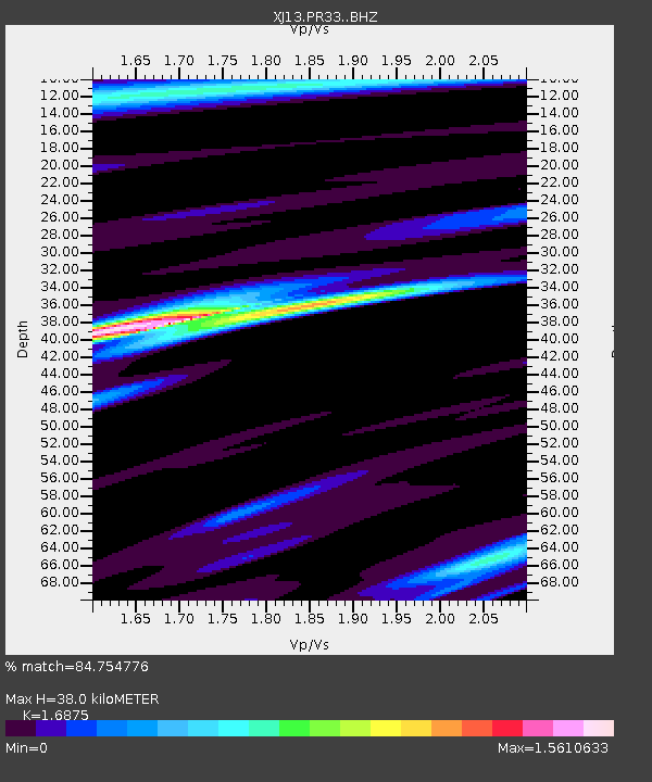
PR33 Engutoto Boma - Earthquake Result Viewer

Earthquake location: Nicobar Islands, India Region
Earthquake latitude/longitude: 7.8/94.3
Earthquake time(UTC): 2014/03/21 (080) 13:41:07 GMT
Earthquake Depth: 10 km
Earthquake Magnitude: 6.5 MWB, 6.4 MWC, 6.4 MWB, 6.4 MWW
Earthquake Catalog/Contributor: NEIC PDE/NEIC COMCAT
Network: XJ CRAFTI
Station: PR33 Engutoto Boma
Lat/Lon: 2.84 S/36.14 E
Elevation: 1101 m
Distance: 59.0 deg
Az: 261.988 deg
Baz: 79.253 deg
Ray Param: 0.062483374
Estimated Moho Depth: 38.0 km
Estimated Crust Vp/Vs: 1.69
Assumed Crust Vp: 6.601 km/s
Estimated Crust Vs: 3.912 km/s
Estimated Crust Poisson's Ratio: 0.23
Radial Match: 84.754776 %
Radial Bump: 400
Transverse Match: 73.965164 %
Transverse Bump: 400
SOD ConfigId: 3390531
Insert Time: 2019-04-10 19:16:39.605 +0000
GWidth: 2.5
Max Bumps: 400
Tol: 0.001

Signal To Noise

ChannelStoNSTALTA
XJ:PR33: :BHZ:20140321T13:50:36.320007Z2.89117032.428825E-78.400836E-8
XJ:PR33: :BHN:20140321T13:50:36.320007Z1.0867791.4995076E-71.3797724E-7
XJ:PR33: :BHE:20140321T13:50:36.320007Z0.497275441.266329E-72.546534E-7
Arrivals
Ps4.2 SECOND
PpPs15 SECOND
PsPs/PpSs19 SECOND