You are here: Home > Network List > CD - China Digital Seismograph Network Stations List
> Station WMQ Urumqi, Xinjiang Province, China > Earthquake Result Viewer
WMQ Urumqi, Xinjiang Province, China - Earthquake Result Viewer

| Earthquake location: |
Java Sea |
| Earthquake latitude/longitude: |
-5.6/110.2 |
| Earthquake time(UTC): |
1994/11/15 (319) 20:18:11 GMT |
| Earthquake Depth: |
559 km |
| Earthquake Magnitude: |
6.2 MB, 6.5 UNKNOWN, 6.5 MW |
| Earthquake Catalog/Contributor: |
WHDF/NEIC |
|
| Network: |
CD China Digital Seismograph Network |
| Station: |
WMQ Urumqi, Xinjiang Province, China |
| Lat/Lon: |
43.82 N/87.69 E |
| Elevation: |
903 m |
|
| Distance: |
53.2 deg |
| Az: |
339.765 deg |
| Baz: |
151.602 deg |
| Ray Param: |
0.06379421 |
| Estimated Moho Depth: |
62.5 km |
| Estimated Crust Vp/Vs: |
1.89 |
| Assumed Crust Vp: |
6.242 km/s |
| Estimated Crust Vs: |
3.298 km/s |
| Estimated Crust Poisson's Ratio: |
0.31 |
|
| Radial Match: |
85.63561 % |
| Radial Bump: |
397 |
| Transverse Match: |
74.27667 % |
| Transverse Bump: |
400 |
| SOD ConfigId: |
4480 |
| Insert Time: |
2010-02-26 21:24:55.549 +0000 |
| GWidth: |
2.5 |
| Max Bumps: |
400 |
| Tol: |
0.001 |
|
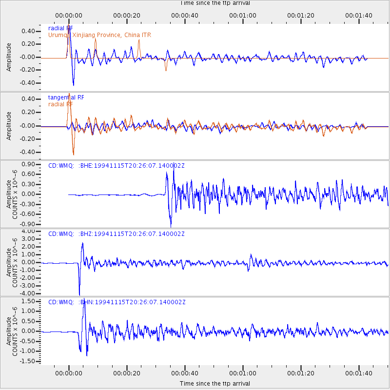
Signal To Noise
| Channel | StoN | STA | LTA |
| CD:WMQ: :BHZ:19941115T20:26:07.140002Z | 95.78345 | 1.1164486E-6 | 1.1655966E-8 |
| CD:WMQ: :BHN:19941115T20:26:07.140002Z | 27.230703 | 3.424231E-7 | 1.257489E-8 |
| CD:WMQ: :BHE:19941115T20:26:07.140002Z | 36.707108 | 2.4657112E-7 | 6.7172583E-9 |
| Arrivals |
| Ps | 9.3 SECOND |
| PpPs | 28 SECOND |
| PsPs/PpSs | 37 SECOND |


