You are here: Home > Network List > TA - USArray Transportable Network (new EarthScope stations) Stations List
> Station Q36A Arnold C. Orvedal, Lecompton, KS, USA > Earthquake Result Viewer
Q36A Arnold C. Orvedal, Lecompton, KS, USA - Earthquake Result Viewer
| Earthquake location: |
Chile-Bolivia Border Region |
| Earthquake latitude/longitude: |
-21.7/-68.2 |
| Earthquake time(UTC): |
2011/06/20 (171) 16:36:01 GMT |
| Earthquake Depth: |
128 km |
| Earthquake Magnitude: |
6.0 MB, 6.5 MW, 6.5 MW |
| Earthquake Catalog/Contributor: |
WHDF/NEIC |
|
| Network: |
TA USArray Transportable Network (new EarthScope stations) |
| Station: |
Q36A Arnold C. Orvedal, Lecompton, KS, USA |
| Lat/Lon: |
38.96 N/95.46 W |
| Elevation: |
306 m |
|
| Distance: |
65.5 deg |
| Az: |
336.92 deg |
| Baz: |
152.12 deg |
| Ray Param: |
0.057866294 |
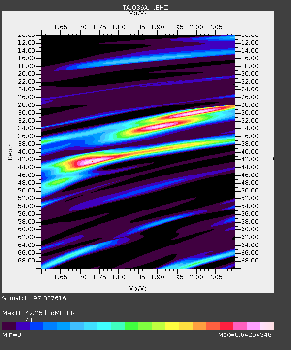
| Estimated Moho Depth: |
42.25 km |
| Estimated Crust Vp/Vs: |
1.73 |
| Assumed Crust Vp: |
6.498 km/s |
| Estimated Crust Vs: |
3.756 km/s |
| Estimated Crust Poisson's Ratio: |
0.25 |
|
| Radial Match: |
97.837616 % |
| Radial Bump: |
400 |
| Transverse Match: |
91.66968 % |
| Transverse Bump: |
400 |
| SOD ConfigId: |
395004 |
| Insert Time: |
2011-12-01 06:28:57.038 +0000 |
| GWidth: |
2.5 |
| Max Bumps: |
400 |
| Tol: |
0.001 |
|
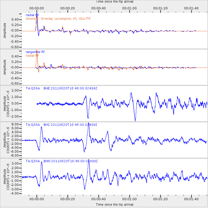
Signal To Noise
| Channel | StoN | STA | LTA |
| TA:Q36A: :BHZ:20110620T16:46:00.02499Z | 31.669542 | 3.4502093E-6 | 1.08944086E-7 |
| TA:Q36A: :BHN:20110620T16:46:00.02499Z | 14.967078 | 1.6668808E-6 | 1.1136982E-7 |
| TA:Q36A: :BHE:20110620T16:46:00.02499Z | 9.835409 | 1.0015809E-6 | 1.0183419E-7 |
| Arrivals |
| Ps | 5.0 SECOND |
| PpPs | 17 SECOND |
| PsPs/PpSs | 22 SECOND |


