You are here: Home > Network List > TA - USArray Transportable Network (new EarthScope stations) Stations List
> Station O35A Humboldt, NE, USA > Earthquake Result Viewer
O35A Humboldt, NE, USA - Earthquake Result Viewer
| Earthquake location: |
Chile-Bolivia Border Region |
| Earthquake latitude/longitude: |
-21.7/-68.2 |
| Earthquake time(UTC): |
2011/06/20 (171) 16:36:01 GMT |
| Earthquake Depth: |
128 km |
| Earthquake Magnitude: |
6.0 MB, 6.5 MW, 6.5 MW |
| Earthquake Catalog/Contributor: |
WHDF/NEIC |
|
| Network: |
TA USArray Transportable Network (new EarthScope stations) |
| Station: |
O35A Humboldt, NE, USA |
| Lat/Lon: |
40.27 N/95.91 W |
| Elevation: |
342 m |
|
| Distance: |
66.8 deg |
| Az: |
337.253 deg |
| Baz: |
151.97 deg |
| Ray Param: |
0.05700731 |
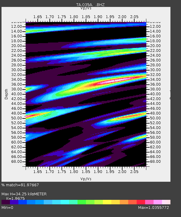
| Estimated Moho Depth: |
34.25 km |
| Estimated Crust Vp/Vs: |
1.97 |
| Assumed Crust Vp: |
6.498 km/s |
| Estimated Crust Vs: |
3.302 km/s |
| Estimated Crust Poisson's Ratio: |
0.33 |
|
| Radial Match: |
91.97667 % |
| Radial Bump: |
400 |
| Transverse Match: |
77.673256 % |
| Transverse Bump: |
400 |
| SOD ConfigId: |
395004 |
| Insert Time: |
2011-12-01 06:29:15.780 +0000 |
| GWidth: |
2.5 |
| Max Bumps: |
400 |
| Tol: |
0.001 |
|

Signal To Noise
| Channel | StoN | STA | LTA |
| TA:O35A: :BHZ:20110620T16:46:08.375027Z | 19.585648 | 2.4439412E-6 | 1.2478225E-7 |
| TA:O35A: :BHN:20110620T16:46:08.375027Z | 4.301989 | 9.758595E-7 | 2.2683915E-7 |
| TA:O35A: :BHE:20110620T16:46:08.375027Z | 4.574512 | 1.0398062E-6 | 2.2730428E-7 |
| Arrivals |
| Ps | 5.3 SECOND |
| PpPs | 15 SECOND |
| PsPs/PpSs | 20 SECOND |


