You are here: Home > Network List > TA - USArray Transportable Network (new EarthScope stations) Stations List
> Station P34A Walnut Farm, Randolph, KS, USA > Earthquake Result Viewer
P34A Walnut Farm, Randolph, KS, USA - Earthquake Result Viewer
| Earthquake location: |
Chile-Bolivia Border Region |
| Earthquake latitude/longitude: |
-21.7/-68.2 |
| Earthquake time(UTC): |
2011/06/20 (171) 16:36:01 GMT |
| Earthquake Depth: |
128 km |
| Earthquake Magnitude: |
6.0 MB, 6.5 MW, 6.5 MW |
| Earthquake Catalog/Contributor: |
WHDF/NEIC |
|
| Network: |
TA USArray Transportable Network (new EarthScope stations) |
| Station: |
P34A Walnut Farm, Randolph, KS, USA |
| Lat/Lon: |
39.55 N/96.83 W |
| Elevation: |
429 m |
|
| Distance: |
66.5 deg |
| Az: |
336.204 deg |
| Baz: |
150.969 deg |
| Ray Param: |
0.057197716 |
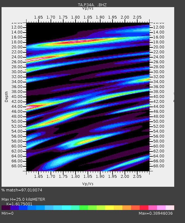
| Estimated Moho Depth: |
25.0 km |
| Estimated Crust Vp/Vs: |
1.62 |
| Assumed Crust Vp: |
6.483 km/s |
| Estimated Crust Vs: |
4.008 km/s |
| Estimated Crust Poisson's Ratio: |
0.19 |
|
| Radial Match: |
97.018074 % |
| Radial Bump: |
366 |
| Transverse Match: |
85.81729 % |
| Transverse Bump: |
400 |
| SOD ConfigId: |
395004 |
| Insert Time: |
2011-12-01 06:30:31.009 +0000 |
| GWidth: |
2.5 |
| Max Bumps: |
400 |
| Tol: |
0.001 |
|

Signal To Noise
| Channel | StoN | STA | LTA |
| TA:P34A: :BHZ:20110620T16:46:06.52499Z | 34.966274 | 3.2550493E-6 | 9.30911E-8 |
| TA:P34A: :BHN:20110620T16:46:06.52499Z | 11.138662 | 1.1556243E-6 | 1.0374894E-7 |
| TA:P34A: :BHE:20110620T16:46:06.52499Z | 8.416554 | 8.5767607E-7 | 1.0190346E-7 |
| Arrivals |
| Ps | 2.5 SECOND |
| PpPs | 9.7 SECOND |
| PsPs/PpSs | 12 SECOND |


