You are here: Home > Network List > TA - USArray Transportable Network (new EarthScope stations) Stations List
> Station L35A Bielow Farm, Ricketts, IA, USA > Earthquake Result Viewer
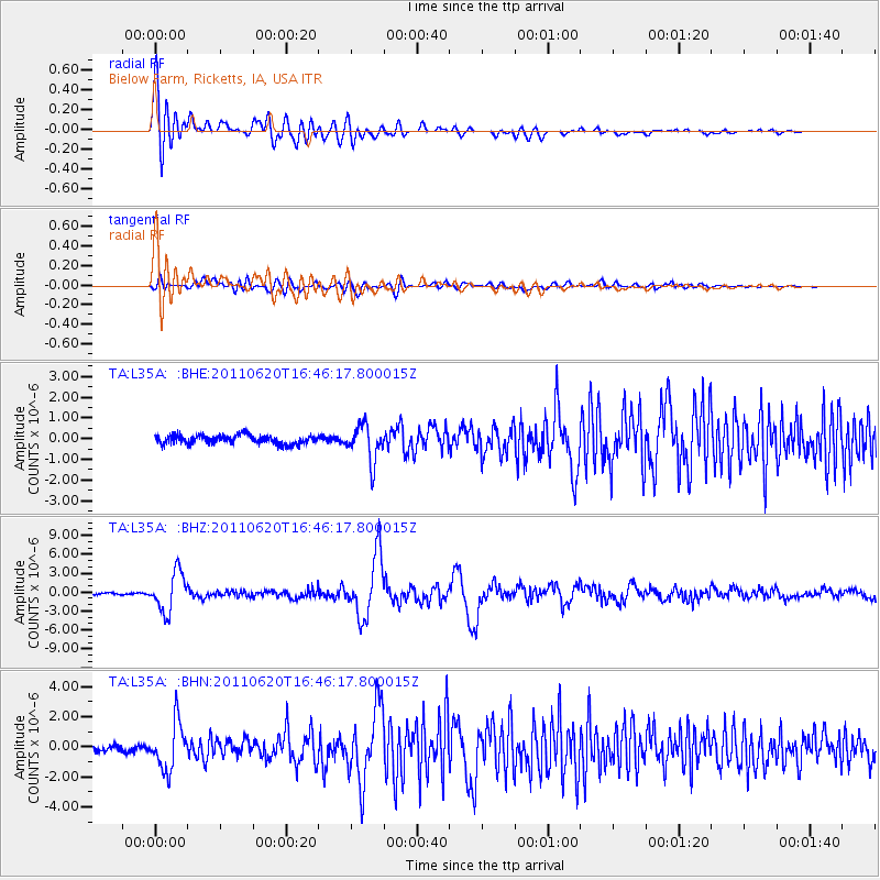
L35A Bielow Farm, Ricketts, IA, USA - Earthquake Result Viewer
| Earthquake location: |
Chile-Bolivia Border Region |
| Earthquake latitude/longitude: |
-21.7/-68.2 |
| Earthquake time(UTC): |
2011/06/20 (171) 16:36:01 GMT |
| Earthquake Depth: |
128 km |
| Earthquake Magnitude: |
6.0 MB, 6.5 MW, 6.5 MW |
| Earthquake Catalog/Contributor: |
WHDF/NEIC |
|
| Network: |
TA USArray Transportable Network (new EarthScope stations) |
| Station: |
L35A Bielow Farm, Ricketts, IA, USA |
| Lat/Lon: |
42.11 N/95.54 W |
| Elevation: |
410 m |
|
| Distance: |
68.3 deg |
| Az: |
338.444 deg |
| Baz: |
152.663 deg |
| Ray Param: |
0.056031834 |
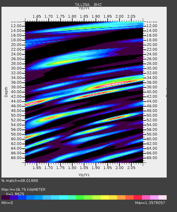
| Estimated Moho Depth: |
36.75 km |
| Estimated Crust Vp/Vs: |
1.96 |
| Assumed Crust Vp: |
6.53 km/s |
| Estimated Crust Vs: |
3.328 km/s |
| Estimated Crust Poisson's Ratio: |
0.32 |
|
| Radial Match: |
89.01998 % |
| Radial Bump: |
400 |
| Transverse Match: |
70.48954 % |
| Transverse Bump: |
400 |
| SOD ConfigId: |
395004 |
| Insert Time: |
2011-12-01 06:31:06.503 +0000 |
| GWidth: |
2.5 |
| Max Bumps: |
400 |
| Tol: |
0.001 |
|
Signal To Noise
| Channel | StoN | STA | LTA |
| TA:L35A: :BHZ:20110620T16:46:17.800015Z | 27.276604 | 3.0724739E-6 | 1.1264136E-7 |
| TA:L35A: :BHN:20110620T16:46:17.800015Z | 7.611876 | 1.5249668E-6 | 2.0034047E-7 |
| TA:L35A: :BHE:20110620T16:46:17.800015Z | 4.1117887 | 8.7332717E-7 | 2.1239592E-7 |
| Arrivals |
| Ps | 5.6 SECOND |
| PpPs | 16 SECOND |
| PsPs/PpSs | 22 SECOND |


