You are here: Home > Network List > TA - USArray Transportable Network (new EarthScope stations) Stations List
> Station V37A Hulbert, OK, USA > Earthquake Result Viewer
V37A Hulbert, OK, USA - Earthquake Result Viewer
| Earthquake location: |
Chile-Bolivia Border Region |
| Earthquake latitude/longitude: |
-21.7/-68.2 |
| Earthquake time(UTC): |
2011/06/20 (171) 16:36:01 GMT |
| Earthquake Depth: |
128 km |
| Earthquake Magnitude: |
6.0 MB, 6.5 MW, 6.5 MW |
| Earthquake Catalog/Contributor: |
WHDF/NEIC |
|
| Network: |
TA USArray Transportable Network (new EarthScope stations) |
| Station: |
V37A Hulbert, OK, USA |
| Lat/Lon: |
35.88 N/95.14 W |
| Elevation: |
219 m |
|
| Distance: |
62.7 deg |
| Az: |
335.562 deg |
| Baz: |
151.721 deg |
| Ray Param: |
0.059700772 |
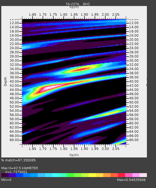
| Estimated Moho Depth: |
42.5 km |
| Estimated Crust Vp/Vs: |
1.74 |
| Assumed Crust Vp: |
6.498 km/s |
| Estimated Crust Vs: |
3.74 km/s |
| Estimated Crust Poisson's Ratio: |
0.25 |
|
| Radial Match: |
97.355095 % |
| Radial Bump: |
264 |
| Transverse Match: |
90.4272 % |
| Transverse Bump: |
400 |
| SOD ConfigId: |
395004 |
| Insert Time: |
2011-12-01 06:31:31.672 +0000 |
| GWidth: |
2.5 |
| Max Bumps: |
400 |
| Tol: |
0.001 |
|

Signal To Noise
| Channel | StoN | STA | LTA |
| TA:V37A: :BHZ:20110620T16:45:41.574978Z | 66.33264 | 4.270241E-6 | 6.437615E-8 |
| TA:V37A: :BHN:20110620T16:45:41.574978Z | 19.303394 | 1.6353224E-6 | 8.471683E-8 |
| TA:V37A: :BHE:20110620T16:45:41.574978Z | 12.582575 | 7.774729E-7 | 6.1789656E-8 |
| Arrivals |
| Ps | 5.0 SECOND |
| PpPs | 17 SECOND |
| PsPs/PpSs | 22 SECOND |


