You are here: Home > Network List > TA - USArray Transportable Network (new EarthScope stations) Stations List
> Station L32A Elgin, NE, USA > Earthquake Result Viewer
L32A Elgin, NE, USA - Earthquake Result Viewer
| Earthquake location: |
Chile-Bolivia Border Region |
| Earthquake latitude/longitude: |
-21.7/-68.2 |
| Earthquake time(UTC): |
2011/06/20 (171) 16:36:01 GMT |
| Earthquake Depth: |
128 km |
| Earthquake Magnitude: |
6.0 MB, 6.5 MW, 6.5 MW |
| Earthquake Catalog/Contributor: |
WHDF/NEIC |
|
| Network: |
TA USArray Transportable Network (new EarthScope stations) |
| Station: |
L32A Elgin, NE, USA |
| Lat/Lon: |
42.00 N/98.01 W |
| Elevation: |
586 m |
|
| Distance: |
69.1 deg |
| Az: |
336.658 deg |
| Baz: |
150.372 deg |
| Ray Param: |
0.055521224 |
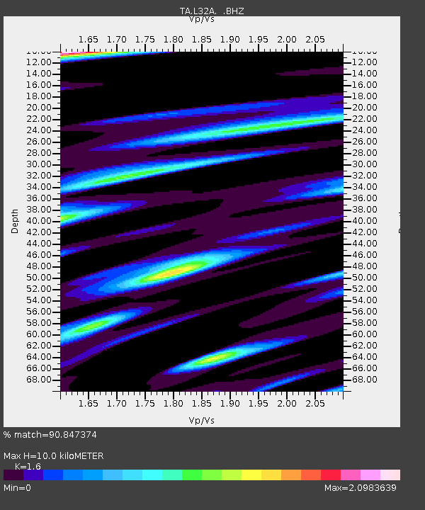
| Estimated Moho Depth: |
10.0 km |
| Estimated Crust Vp/Vs: |
1.60 |
| Assumed Crust Vp: |
6.53 km/s |
| Estimated Crust Vs: |
4.082 km/s |
| Estimated Crust Poisson's Ratio: |
0.18 |
|
| Radial Match: |
90.847374 % |
| Radial Bump: |
400 |
| Transverse Match: |
86.39014 % |
| Transverse Bump: |
400 |
| SOD ConfigId: |
395004 |
| Insert Time: |
2011-12-01 06:33:02.457 +0000 |
| GWidth: |
2.5 |
| Max Bumps: |
400 |
| Tol: |
0.001 |
|
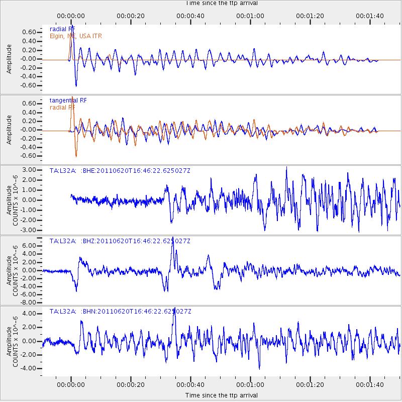
Signal To Noise
| Channel | StoN | STA | LTA |
| TA:L32A: :BHZ:20110620T16:46:22.625027Z | 15.215937 | 2.288608E-6 | 1.5040861E-7 |
| TA:L32A: :BHN:20110620T16:46:22.625027Z | 4.708964 | 1.35293E-6 | 2.8730946E-7 |
| TA:L32A: :BHE:20110620T16:46:22.625027Z | 4.0339785 | 9.779873E-7 | 2.424374E-7 |
| Arrivals |
| Ps | 1.0 SECOND |
| PpPs | 3.8 SECOND |
| PsPs/PpSs | 4.8 SECOND |


